Updated Sept. 6, 2019 – 2100z
- Overview
- Update from the National Hurricane Center
- Airport & Equipment Information
- Route Information
- Operational Resources
- Dorian Relief Efforts for the Bahamas
- NBAA’s HERO Database
Overview
This will be the final full update regarding Dorian as the FAA Command Center has hosted their last hurricane telcon.
Dorian is well off the east coast, even with Virginia right now and picking up speed as it moves to the northeast. It should pass east of the Cape Island airports overnight, bringing wind and rain with the outer bands, but no significant airspace issues.
A few takeaways:
- The Bahamas have finally issued a number of NOTAMs with information regarding contact information for access to Abaco and Grand Bahama.
- A second AFP was added to help manage traffic into the Bahamas today. This is a fluid situation and may transfer to some other sort of program, like required slots or a TFR.
- Traffic in the northeast is being kept off the coast right now due to turbulence reports, and that may continue to impact international flights as this thing remains a hurricane through impact to Nova Scotia tomorrow afternoon.
Update from the National Hurricane Center
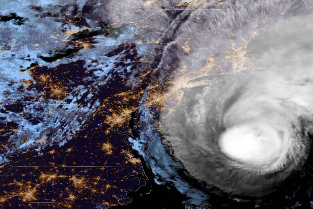
According to the National Hurricane Center’s Advisory #54, issued at 2100z::
At 500 PM EDT (2100 UTC), the eye of Hurricane Dorian was located near latitude 36.9 North, longitude 72.7 West. Dorian is moving toward the northeast near 24 mph (39 km/h), and this general motion with an additional increase in forward speed is expected through Sunday. On the forecast track, the center of Dorian should move move to the southeast of extreme southeastern New England tonight and Saturday morning, and then across Nova Scotia late Saturday or Saturday night.
Maximum sustained winds are near 90 mph (150 km/h) with higher gusts. Some strengthening is possible during the next 24 hours. After that time, Dorian is forecast to become a post-tropical cyclone with hurricane-force winds Saturday night or Sunday while it is near or over eastern Canada.
Hurricane-force winds extend outward up to 80 miles (130 km) from the center and tropical-storm-force winds extend outward up to 230 miles (370 km).
The estimated minimum central pressure is 958 mb (28.29 inches).
Airport & Equipment Information
Airport Impacts
The Bahamians have finally issued NOTAMs regarding access to Abaco and the Grand Bahamas. We are also adding information to our “Dorian Resources” page with a form that they are going to ask you to fill out for access to the islands.
No US airport closures remain at this time.
Equipment
Protective Shutdowns:
CAROLINAS:
- WILMINGTON, NC (ILM) RWY 06/24 (GNM/GMX) LOC/GS.
Unscheduled Outages:
CAROLINAS:
- COLUMBIA, SC (CAE) VOR UNMONITORED.
- HATTERAS, NC (HAT) RCO.
- KINSTON, NC (ISO) VOR UNMONITORED.
BAHAMA:
- GRAND BAHAMA, BH (BHF) ATCBI.
- GRAND BAHAMA, BH (BHF) RCAG (132.95/123.675/134.2/363.05 MHZ).
- GRAND BAHAMA, BH (BHF) RCO (126.9 MHZ).
- SOUTH BIMINI, BH (ZBV) RCO. VOR UNMONITORED
IF THERE ARE ANY QUESTIONS, PLEASE CONTACT NOCC AT (540)359-3110.
Route Information
As noted above, traffic is being routed tactically around areas still being impacted by hurricane Dorian, mostly due to turbulence issues. This could continue through the weekend as Dorian makes its way past Newfoundland on Sunday.
Operational Resources
- National Hurricane Center
- FAA OIS page
- CADENA OIS page
- FAA Advisory Database
- FAA Current Reroutes
- FAA NOTAM Search
Dorian Relief Efforts for the Bahamas
The South Florida Business Aviation Association (SFBAA) and others in the business aviation community are collecting supplies in support of relief efforts in the Bahamas. Learn more about what supplies are needed and how you can help.
NBAA’s HERO Database
The NBAA Humanitarian Emergency Response Operator (HERO) Database is a list of people in the business aviation community who are part of disaster-response mobilization efforts. In the aftermath of major crises, basic information from the database is provided to organizations coordinating relief efforts. Learn more and register.