Updated Sep 29, 2022 – 1230z
- Overview
- Update from the National Hurricane Center
- Airport & Equipment Information
- Route Information
- Operational Resources
- NBAA’s HERO Database
Overview
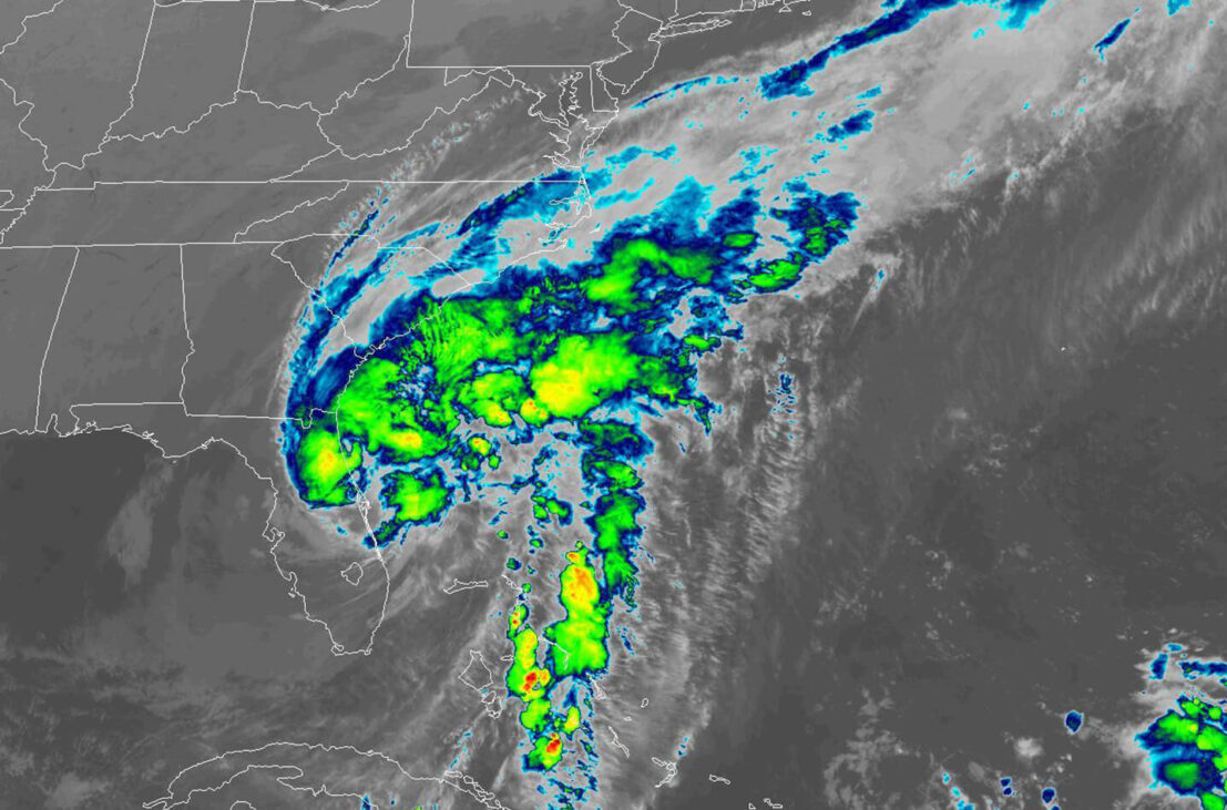
Hurricane Ian moved across the central portion of Florida overnight and diminished to a tropical storm. Ian was located 40 miles east of Orlando near Cape Canaveral at 0800 EDT this morning with maximum sustained winds of 65 mph. Significant damage across the state has many airports closed today with an emphasis on search and rescue and damage assessment as today’s primary objectives. Some airports are open to emergency response aircraft and military operations only.
Tropical Storm Ian remains a serious threat with catastrophic flooding expected over portions of east-central Florida. The current track of Tropical Storm Ian has the storm moving out into the Atlantic Ocean off the Florida coast with a turn to the north-northwest expected this evening reaching the southern portion of the South Carolina coastline Friday afternoon. Ian is expected to remain a tropical storm and there remains a small chance it could reach a category 1 hurricane before reaching South Carolina tomorrow. Tropical Storm conditions are possible tomorrow from Cedar Island, NC down to Jacksonville, FL. The storm will push northwestward Friday night into western North Carolina and southwest Virgnia by Saturday afternoon.
Update from the National Hurricane Center
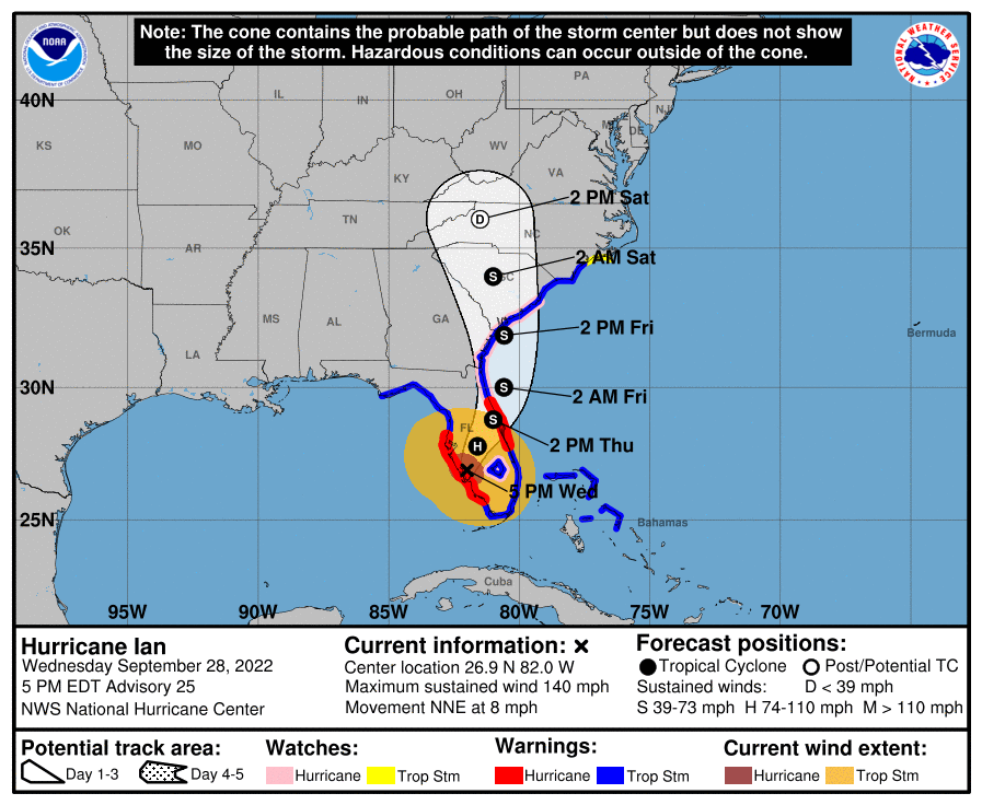
According to the National Hurricane Center’s Advisory #27A, issued at 1200z:
At 800 AM EDT (1200 UTC), the center of Tropical Storm Ian was located near latitude 28.5 North, longitude 80.7 West. Ian is moving toward the northeast near 8 mph (13 km/h). A turn toward the north-northeast is expected later today, followed by a turn toward the north and north-northwest with an increase in forward speed Friday and Friday night. On the forecast track, the center of Ian is expected to move off the east-central coast of Florida soon and then approach the coast of South Carolina on Friday. The center will move farther inland across the Carolinas Friday night and Saturday.
Maximum sustained winds remain near 65 mph (100 km/h) with higher gusts. Some re-intensification is forecast, and Ian could be near hurricane strength when it approaches the coast of South Carolina on Friday. Weakening is expected Friday night and Saturday after Ian moves inland.
Tropical-storm-force winds extend outward up to 415 miles (665 km) from the center. Daytona Beach International Airport recently reported a sustained wind of 60 mph (97 km/h) and a gust to 70 mph (113 km/h).
The estimated minimum central pressure is 987 mb (29.15 inches) based on surface observations.
Airport & Equipment Information
Airport Closures
- TPA closed until Sep 30 at 1600z
- SRQ closed until Sep 30 at 0000z
- RSW closed to all operations other than humanitarian until Sep 30 at 1600z (30 minute PPR required via phone 239-590-4460)
- PIE closed until Sep 30 at 1600z
- APF closed until Sep 29 at 1600z (subject to change and possible extension)
- MCO closed to all operation other than emergency and military until Sep 30 at 1430z
- ORL closed to all operations other than emergency and military until Sep 30 at 1600z (2 hour PPR required via phone 407-825-1681)
- ISM closed to all operations other than emergency flights until Oct 01 at 1059z
- EYW closed until Sep 29 at 1100z
- DAB closed to all operations other than emergency and military until Oct 05 at 2200z (1 hour PPR required via phone 386-547-0298)
- VRB closed until Sep 30 at 1100z
- VDF closed until Oct 01 at 2100z
- SGJ closed until Oct 01 at 1600z
- LEE closed until Sep 30 at 1059z
- PGD closed until Sep 29 at 1800z
- SFB closed until Sep 30 at 2100z
- SPG closed until Sep 30 at 1100z
- MLB closed until Sep 30 at 1400z
Unscheduled System Failures
- DAYTONA BEACH, FL (DAB) GBTS OTS.
- FT GREEN, FL (FN7) ARSR (RDAT/BDAT) OTS.
- FT MEYERS, FL (FMY) RCAG OTS.
- FT MEYERS, FL (FMY) BUEC OTS.
- KEY WEST, FL (Q55) ATIS OTS.
- KEY WEST, FL (EYW) GBTS OTS.
- KEY WEST, FL (EYW) BUEC OTS.
- MARATHON, FL (MTH) FCOM OTS.
- MIAMI, FL (MIA) RWY 26L (VIN) GS OTS.
- OKEECHOBEE, FL (OBE) GBTS OTS.
- ORLANDO, FL (MCO) GBTS OTS.
- PAHOKEE, FL (PHK) RCAG OTS.
- SANFORD, FL (SFB) RWY 09R (OOS) LOC OTS.
- SARASOTA, FL (X06) GBTS OTS.
- ST. AUGUSTINE (SGJ) BUEC OTS.
Protective Shutdowns
- COCOA BEACH, FL XMR FDAT UFN.
- DAYTONA BEACH, FL (DAB) ASR UFH.
- DAYTONA BEACH, FL (DAB) MODES UFN.
- FT MYERS, FL (FMY) ASR UFN.
- FT MYERS, FL (FMY) RVR UFN.
- FT MYERS, FL (FMY) RWY 06 (RSW) MALSR UFN.
- FT MYERS, FL (RSWT) TISB UFN.
- FT MYERS, FL (FMY) SAWS UFN.
- GAINSVILLE, FL (GNV) ASR UFN.
- GAINSVILLE, FL (GNV) MODES UFN.
- JACKSONVILLE, FL (JAX) ASR UFN.
- JACKSONVILLE, FL (JAX) MODES UFN.
- JACKSONVILLE, FL (JAX) RWY 08 (JAX) LOC UFN.
- JACKSONVILLE, FL (JAX) RWY 08 (JAX) GS UFN.
- KISSIMMEE, FL (ISM) RWY 15 (ISM) LOC UFN.
- KISSIMMEE, FL (ISM) RWY 15 (ISM) GS UFN.
- KISSIMMEE, FL (ISM) RWY 15 (ISM) DME UFN.
- KISSIMMEE, FL (ISM) RWY 15 (ISM) MALSF UFN.
- LAKELAND, FL (LALA) RWY 10 ALS SX WAS DISCONNECTED.
- NEW SMYRNA, FL EVB FDAT UFN.
- ORLANDO, FL (ORL) RWY 07 (ORL) MALSR UFN.
- ORLANDO, FL (ORL) RWY 07 (ORL) GS UFN.
- ORLANDO, FL (ORL) RWY 25 (EXO) LOC UFN.
- ORLANDO, FL (ORL) RWY 25 (EXO) GS UFN.
- ORLANDO, FL (ORL) RWY 25 (EXO) PAPI UFN.
- ORLANDO, FL (MCO) RWY 18R (TFE) DME UFN.
- ORLANDO, FL (MCO) RWY 36R (TFE) LOC UFN.
- ORLANDO, FL (MCO) RWY 36R (TFE) GS UFN.
- ORLANDO, FL (MCO) RWY 18R (TFE) MALSR UFN.
- ORLANDO, FL (MCO) RWY 18R (OJP) LOC UFN.
- ORLANDO, FL (MCO) RWY 18R (OJP) GS UFN.
- ORLANDO, FL (MCO) RWY 36R (OJP) PAPI UFN.
- ORLANDO, FL (MCO) RWY 35R (CER) LOC UFN.
- ORLANDO, FL (MCO) RWY 35R ( ER) GS UFN.
- ORLANDO, FL (MCO) RWY 35R (CER) DME UFN.
- ORLANDO, FL (MCO) RWY 35R (CER) ALS UFN.
- ORLANDO, FL (MCO) RWY 35R (CER) PAPI UFN.
- ORLANDO, FL (MCO) RWY 17L (ARK) LOC UFN.
- ORLANDO, FL (MCO) RWY 17L (ARK) GS UFN.
- ORLANDO, FL (MCO) RWY 17L (ARK) DME UFN.
- ORLANDO, FL (MCO) RWY 17L (ARK) PAPI UFN.
- ORLANDO, FL (MCO) RWY 17R (DIZ) LOC UFN.
- ORLANDO, FL (MCO) RWY 17R (DIZ) GS UFN.
- ORLANDO, FL (MCO) RWY 17R (DIZ) DME UFN.
- ORLANDO, FL (MCO) RWY 17L (ARK) ALS UFN.
- ORLANDO, FL (MCO) RWY 17L (ARK) PAPI UFN.
- ORLANDO, FL (MCO) RWY 35L (DDO) LOC UFN.
- ORLANDO, FL (MCO) RWY 35L (DDO) GS UFN.
- ORLANDO, FL (MCO) RWY 35L (DDO) DME UFN.
- ORLANDO, FL (MCO) RWY 35L (DDO) ALS UFN.
- ORLANDO, FL (MCO) RWY 35L (DDO) PAPI UFN.
- ORLANDO, FL (MCO) SX UFN.
- ORLANDO, FL (MCO) RWY 18L PAPI UFN.
- ORLANDO, FL (MCO) RWY 36L PAPI UFN.
- ORLANDO, FL (MCO) RWY 36L REIL UFN.
- ORLANDO, FL (MCO) ASR UFN.
- ORLANDO, FL (MCO) ASDE UFN.
- PATRICK AFB, FL COF FDAT UFN.
- SARASOTA, FL (SRQ) ASR UFN.
- SARASOTA, FL (SRQ) MODES UFN.
- SARASOTA, FL (SRQT) TISB UFN.
- SARASOTA, FL (SRQ) RWY 14 (FFV) MALSR UFN.
- SARASOTA, FL (SRQ) SAWS UFN.
- SARASOTA, FL (SRQ) RWY 14 (FFV) MALSR UFN.
- ST PETERSBURG, FL (PIE) RWY 18 (PIE) LOC UFN.
- ST PETERSBURG, FL (PIE) RWY 18 (PIE) GS UFN.
- ST PETERSBURG, FL (PIE) RWY 18 (PIE) PAPI UFN
- ST PETERSBURG, FL (PIE) RWY 36 (CWT) LOC UFN.
- ST PETERSBURG, FL (PIE) RWY 36 (CWT) GS UFN.
- ST PETERSBURG, FL (PIE) RWY 36 (CWT) DME UFN.
- ST PETERSBURG, FL (PIE) RWY 36 (CWT) PAPI UFN.
- TAMPA, FL (TPA) ASR UFN.
- TAMPA, FL (TPA) MODES UFN.
- TAMPA, FL (TPA) RWY 19R (JRT) MALSR UFN.
- TAMPA, FL (TPA) RWY 19R (JRT) LOC UFN.
- TAMPA, FL (TPA) RWY 19R (JRT) GS UFN.
- TAMPA, FL (TPA) RWY 19R (JRT) DME UFN.
- TAMPA, FL (TPA) RWY 01L (AMP) LOC UFN.
- TAMPA, FL (TPA) RWY 01L (AMP) GS UFN.
- TAMPA, FL (TPA) RWY 01L (AMP) DME UFN.
- TAMPA, FL (TPA) RWY 01L (AMP) ALS UFN.
- TAMPA, FL (TPA) RVR UFN.
- TAMPA, FL (TPAT) TISB UFN.
- TAMPA, FL (TPA) RWY 19L (TPA) ALS UFN.
- TAMPA, FL (TPA) RWY 19L (TPA) LOC UFN.
- TAMPA, FL (TPA) RWY 19L (TPA) GS UFN.
- TAMPA, FL (TPA) RWY 01R (TWJ) LOC UFN.
- TAMPA, FL (TPA) RWY 01R (TWJ) DME UFN.
- VERO BEACH, FL (VRB) ASR 09/28-30/1300Z.
Route Information
- There are structured routes to southeast Florida from the Northeast and Mid-Atlantic that brings air traffic down the west side of Florida due to convective activity along the Florida Atlantic Coastline and Atlantic AR routes.
- Arrivals into MIA/FLL/PBI can be expected to be routed down the west side of the state.
- AR routes between NC and FL are closed.
- Airways Y493/Y494 in Jacksonville Center are closed until at least 0200z.
Operational Resources
- National Hurricane Center
- FAA OIS page
- CADENA OIS page
- FAA Advisory Database
- FAA Current Reroutes
- FAA NOTAM Search
NBAA’s HERO Database
The NBAA Humanitarian Emergency Response Operator (HERO) Database is a list of people in the business aviation community who are part of disaster-response mobilization efforts. In the aftermath of major crises, basic information from the database is provided to organizations coordinating relief efforts. Learn more and register.