Updated Sept. 27, 2022 – 2230z
- Overview
- Update from the National Hurricane Center
- Airport & Equipment Information
- Route Information
- Operational Resources
- NBAA’s HERO Database
Overview
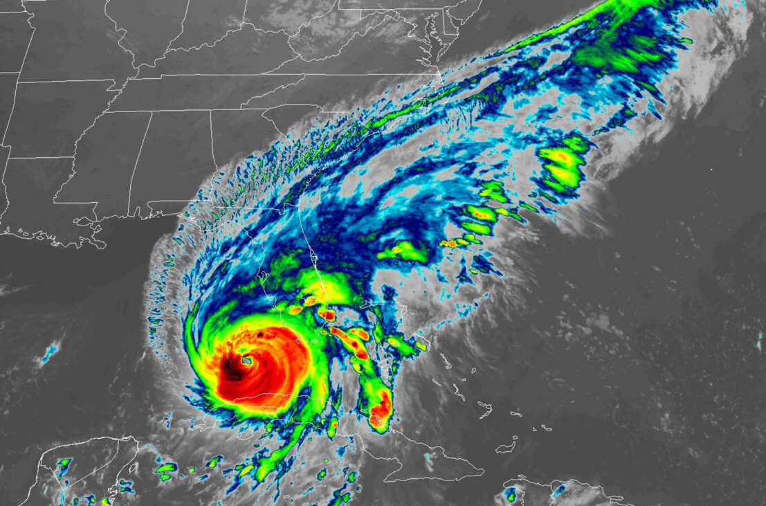
Hurricane Ian is presently located approximately 230 miles south of Sarasota, FL moving northbound at 10 mph. A hurricane warning is in effect from Marco Island, FL north to Tarpon Springs, FL. This area includes the cities of Naples, Ft Myers, Sarasota and Tampa/St Petersburg. A turn toward the north-northeast with a reduction in forward speed is forecast tonight and Wednesday. On the forecast track, the center of Ian is expected to move over the southeastern Gulf of Mexico today, pass west of the Florida Keys later tonight, and approach the west coast of Florida within the hurricane warning area on Wednesday afternoon/evening. Several airports in the region have already closed and more are expected to close by tomorrow morning (details below). This hurricane is expected to bring a major storm surge to the west coastal areas of central and south Florida over the next 48 hours. Heavy rain and strong winds are also expected with the chance of tornadic activity across most of southern Florida.
Update from the National Hurricane Center
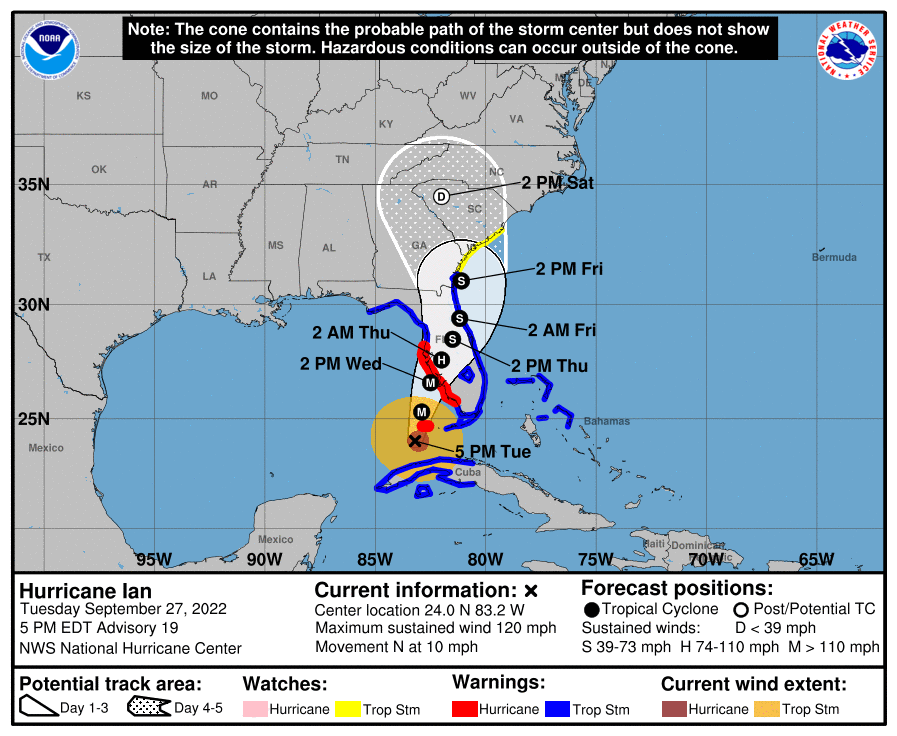
According to the National Hurricane Center’s Advisory #19, issued at 2100z:
At 500 PM EDT (2100 UTC), the center of Hurricane Ian was located near latitude 24.0 North, longitude 83.2 West. Ian is moving toward the north near 10 mph (17 km/h). A turn toward the north-northeast with a reduction in forward speed is forecast tonight and Wednesday. On the forecast track, the center of Ian is expected to move over the southeastern Gulf of Mexico today, pass west of the Florida Keys later tonight, and approach the west coast of Florida within the hurricane warning area on Wednesday and Wednesday night.
Maximum sustained winds remain near 120 mph (195 km/h) with higher gusts. Ian is a category 3 hurricane on the Saffir-Simpson Hurricane Wind Scale. Re-strengthening is expected later today through Wednesday. Ian is forecast to approach the west coast of Florida as an extremely dangerous major hurricane.
Hurricane-force winds extend outward up to 40 miles (65 km) from the center and tropical-storm-force winds extend outward up to 140 miles (220 km).
The estimated minimum central pressure is 952 mb (28.12 inches).
Airport & Equipment Information
Airport Closure Times and Restrictions
- SPG closed as of 1700z
- TPA closed as of 2100z except for emergency
- PIE closed as of 2200z
- IMM closed as of 2200z
- FMY closed as of 28/0000z
- SRQ closed as of 28/0000z
- APF closing at 28/0200z (FBO closing at 2200z)
- SFB closing at 28/0500z except for Search/Rescue operations
- ISM closing at 28/1100z except for emergency (tower closing at 28/0201z)
- MCO closing at 28/1430z except emergency and military operations (2 hour PPR required – call 407-825-1681)
- ORL closing at 28/1430 except for emergency/military operations
- MLB closing at 28/1800z
- EYW ATC Tower closed earlier today
Miami Center (ZMA) will assume Tampa Approach Airspace later this evening.
FAA Tower Closures
ST PETERSBURG, FL (PIE) ATCT ATC ZERO – 0927/2100-0930/1300Z
TAMPA, FL (TPA) ATCT ATC ZERO – 0928/0200-0930/1200Z
SARASOTA, FL (SRQ) ATCT ATC ZERO – 0927/2100-0929/1200Z
PATRICK AFB, FL (COF) ATCT CLOSED – 0927/2018-0930/1200Z
Protective Equipment Shutdowns
FT MYERS, FL (FMY) ASR 0927/2000-0930/1400Z
TAMPA, FL (TPA) ASR 0928/0000-1001/2100Z
TAMPA, FL (TPA) RVR 0927/2100-1002/2000Z
FT MYERS, FL (FMY) RVR 0927/1405-1001/2100Z
FT MYERS, FL (FMY) SAWS 0927/1230-1001/1500Z
SARASOTA, FL (SRQ) RWY 14 (FFV) MALSR 0926/1752-0930/2000Z
SARASOTA, FL (SRQ) RWY 32 (SRQ) MALSR 0927/1039-0930/2000Z
SARASOTA, FL (SRQ) SAWS 09/27/1215-0929/1100Z
TAMPA, FL (TPA) RWY 19R (JRT) MALSR 0926/1800-1001/2000Z
TAMPA, FL (TPA) RWY 19R (JRT) LOC 0927/2100-1002/2200Z
TAMPA, FL (TPA) RWY 19R (JRT) GS 0927/2100-1002/2200Z
TAMPA, FL (TPA) RWY 19R (JRT) DME 0927/2100-1002/2200Z
TAMPA, FL (TPA) RWY 01L (AMP) LOC 0927/2100-1002/2200Z
TAMPA, FL (TPA) RWY 01L (AMP) GS 0927/2100-1002/2200Z
TAMPA, FL (TPA) RWY 01L (AMP) DME 0927/2100-1002/2200Z
TAMPA, FL (TPA) RWY 19L (TPA) LOC 0927/2100-1002/2000Z
TAMPA, FL (TPA) RWY 19L (TPA) GS 0927/2100-1002/2000Z
TAMPA, FL (TPA) RWY 19L (TPA) ALS 0927/1300-1001/2100Z
TAMPA, FL (TPA) RWY 01R (TWJ) LOC 0927/2100-1001/2100Z
TAMPA, FL (TPA) RWY 01R (TWJ) DME 0927/2100-1001/2100Z
TAMPA, FL (TPA) RWY 01L (AMP) ALS 0927/2100-1002/2000Z
Route Information
Severe weather avoidance plans are expected for ZMA airspace and South Florida terminal areas.
Planned Alternate Departure Routes
Departure gates are anticipated to open and close based on the movement of weather. Expect compacted departure routes and swapd to alternate gates. Increased departure delays and MIT associated with severe weather can cause longer than normal departure wait times.
Planned Alternate Arrival Routes
Arrival gates are anticipated to open and close based on the movement of weather. Customers can expect possible playbooks, tactical route adjustments and holding on inbound flights due to convective weather
impacts within ZMA airspace and MIA/FLL/TPA terminal areas.
Fuel Advisory
Operators should fuel in anticipation of departure/arrival gate changes, playbooks, tactical reroutes, holding and other traffic management initiatives due to airspace constraints.
Operational Resources
- National Hurricane Center
- FAA OIS page
- CADENA OIS page
- FAA Advisory Database
- FAA Current Reroutes
- FAA NOTAM Search
NBAA’s HERO Database
The NBAA Humanitarian Emergency Response Operator (HERO) Database is a list of people in the business aviation community who are part of disaster-response mobilization efforts. In the aftermath of major crises, basic information from the database is provided to organizations coordinating relief efforts. Learn more and register.