Updated Sept. 30, 2022 – 2215z
- Overview
- Update from the National Hurricane Center
- Airport & Equipment Information
- Route Information
- Operational Resources
- NBAA’s HERO Database
Overview
Hurricane Ian is moving toward the north at 15 mph. Ian is forecast to turn toward the north-northwest by tonight and will move inland across eastern South Carolina and central North Carolina tonight and Saturday. Maximum sustained winds remain at 70 mph with higher gusts.
Update from the National Hurricane Center
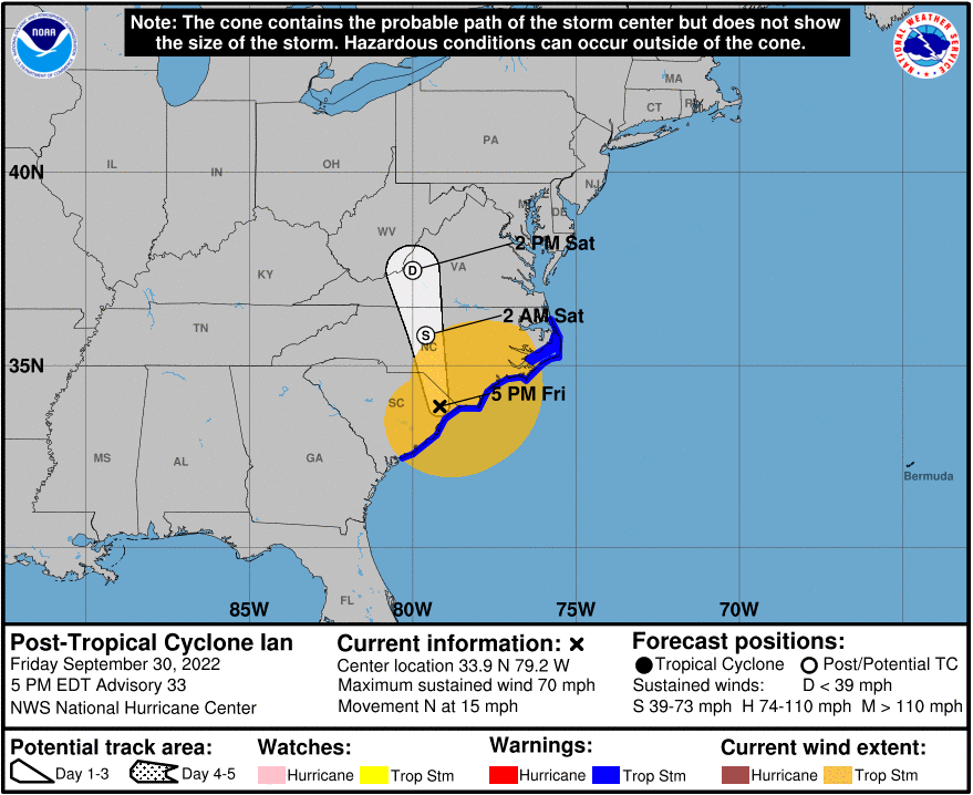
According to the National Hurricane Center’s Advisory #33, issued at 2100Xz:
At 500 PM EDT (2100 UTC), the center of Post-Tropical Cyclone Ian was located near latitude 33.9 North, longitude 79.2 West. The post-tropical cyclone is moving toward the north near 15 mph (24 km/h). Ian is forecast to move farther inland overnight over eastern South Carolina, move across central North Carolina early tomorrow and western Virginia by early Sunday.
Maximum sustained winds have decreased to near 70 mph (110 km/h) with higher gusts. These winds are occurring primarily over water. Ian should continue to weaken overnight and dissipate over western
North Carolina or Virginia late tomorrow.Tropical-storm-force winds extend outward up to 205 miles (335 km) from the center. A WeatherFlow station at Oak Island, North Carolina recently reported sustained winds of 54 mph (87 km/h) with a gust to 78 mph (126 km/h).
The estimated minimum central pressure is 982 mb (29.00 inches) based on surface observations.
Airport & Equipment Information
Airport Closures
Unscheduled System Failures
Florida:
- COW CREEK, FL (QNC) BUECS OTS.
- DAYTONA BEACH, FL (DAB) GBTS OTS.
- FT MYERS, FL (FMY) RWY 05 (RSW) LOC OTS.
- FT MYERS, FL (FMY) RWY 05 (RSW) GS OTS.
- JACKSONVILLE, FL (LRO) GBTS UFN.
- KEY WEST, FL (EYW) GBTS OTS.
- KEY WEST, FL (EYW) BUEC OTS.
- LABELLE, FL (LBV) BUEC OTS.
- MIAMI, FL (MIA) RWY 26L (VIN) GS OTS.
- OKEECHOBEE, FL (OBE) GBTS OTS.
- ORLANDO, FL (ORL) ELVTR OTS UFN.
- ANFORD, FL (SFB) RWY 09R (OOS) LOC OTS.
- SARASOTA, FL (X06) GBTS OTS.
- ST. AUGUSTINE (SGJ) BUEC OTS.
- ST. AUGUSTINE (SGJ) FDIO OTS.
Protective Shutdowns
Florida:
- COCOA BEACH, FL XMR FDAT UFN.
- FT MYERS, FL (FMY) RWY 05 (RSW) LOC UFN.
- FT MYERS, FL (FMY) RWY 05 (RSW) GS UFN.
- FT MYERS, FL (FMY) RWY 06 (RSW) MALSR UFN.
- FT MYERS, FL (RSWT) TISB UFN.
- FT MYERS, FL (FMY) SAWS UFN.
- ST. AUGUSTINE (SGJ) BUEC OTS.
- GAINSVILLE, FL (GNV) MODES UFN.
- LAKELAND, FL (LAL) RWY 10 ALS SX DISCONNECTED.
- NEW SMYRNA, FL (EVB) FDAT UFN.
- SARASOTA, FL (SRQT) TISB UFN.
- TAMPA, FL (TPAT) TISB UFN.
- TAMPA, FL (TPA) RWY 19L (TPA) ALS UFN.
- TAMPA, FL (TPA) RWY 01L (AMP) ALS UFN.
Unscheduled System Failures
South Carolina:
- FLORENCE, SC (FLO) BUECS UFN.
- GEORGETOWN, SC (GGE) BUECS UFN.
Route Information
- ZBW_DCMETS_TO_FL_PARTIAL – for flight going from ZBW and DC Metro’s to Florida
- FL_TO_NE_3_PARTIAL – for flight going from Florida up to the NE.
Operational Resources
- National Hurricane Center
- FAA OIS page
- CADENA OIS page
- FAA Advisory Database
- FAA Current Reroutes
- FAA NOTAM Search
NBAA’s HERO Database
The NBAA Humanitarian Emergency Response Operator (HERO) Database is a list of people in the business aviation community who are part of disaster-response mobilization efforts. In the aftermath of major crises, basic information from the database is provided to organizations coordinating relief efforts. Learn more and register.