Aug 29, 2021 – 1315z
- Overview
- Update from the National Hurricane Center
- Airport & Equipment Information
- Route Information
- Operational Resources
Overview
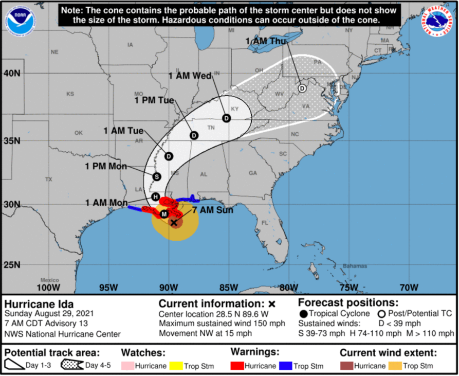
Hurricane Ida has reached Category 4 on the Saffir Simpson scale which will bring catastrophic winds, storm surge and excessive rainfall to the central and southeast Louisiana coastline today into this evening. At 8:00 EDT the storm was centered 50 miles southwest of the mouth of the Mississippi River. As the storm approaches the southeast shores of Louisiana strong winds, rain and storm surge are expected well before the storm makes landfall. New Orleans Lakefront (NEW) is already reporting gusts to 40 knots. Landfall is expected early afternoon with the storm continuing a slow trek northward into the evening. The storm will begin to lose intensity once it moves inland, however is expected to remain a Hurricane well into the early morning hours of Monday.The maximum sustained winds at the center of the storms have increased to near 150 mph with higher gusts.
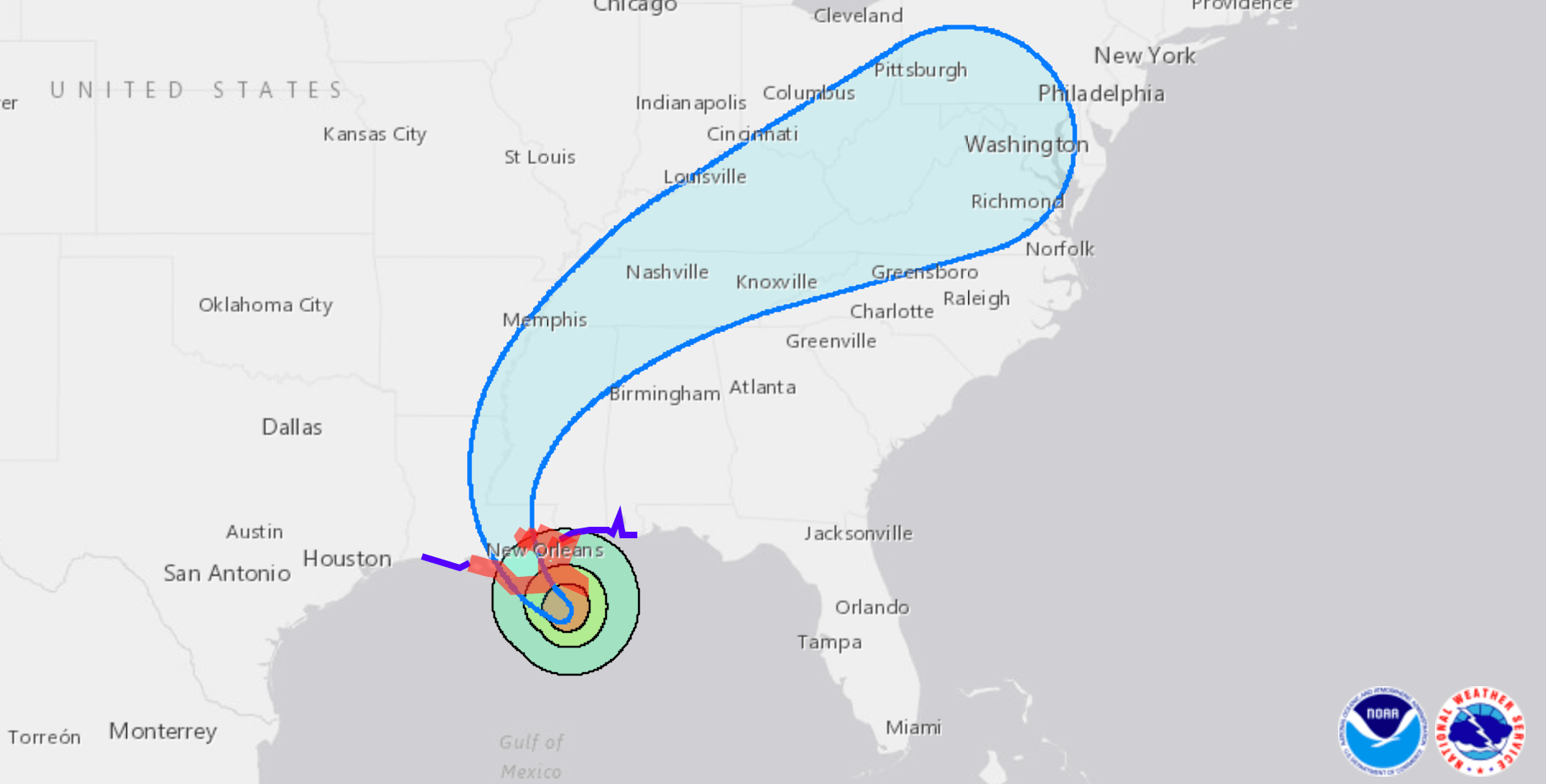
The airport ATC towers at most south Louisiana and Mississippi airports are ATC-Zero including MSY/NEW/LFT/BTR/GPT. Houston Center has advised that A770, L214, A766 and L333 are closed. It is highly likely that we will see Q/Y route closures between Houston and Jacksonville as well. Hurricane force winds extend 50 mile from the center with tropical storm force winds extending outward up to 140 miles. A significant portion of the Gulf Coast from western LA to the FL panhandle will see heavy winds and rainfall with tornadic activity also possible.
Ida – Update from the National Hurricane Center
According to the National Hurricane Center’s Advisory #13, issued at 1200z:
At 700 AM CDT (1200 UTC), the eye of Hurricane Ida was located near latitude 28.5 North, longitude 89.6 West. Ida is moving toward the northwest near 15 mph (24 km/h), and this general motion should continue through tonight and early Monday, followed by a slower northward motion on Monday afternoon. A northeastward turn is forecast by Monday night. On the forecast track, the center of Ida will make landfall along the coast of southeastern Louisiana within the hurricane warning area late this morning or early this afternoon. Ida is then forecast to move well inland over portions of Louisiana and western Mississippi on Monday and Monday night.
Reports from Air Force Reserve and NOAA hurricane hunter aircraft indicate that the maximum sustained winds are near 150 mph (240 km/h) with higher gusts. Ida is an extremely dangerous category 4 hurricane on the Saffir-Simpson Hurricane Wind Scale. Some additional strengthening is forecast, and Ida is expected to be an extremely dangerous major hurricane when it makes landfall along the Louisiana coast. Rapid weakening is expected after landfall.
Hurricane-force winds extend outward up to 50 miles (85 km) from the center and tropical-storm-force winds extend outward up to 140 miles (220 km). An elevated NOAA C-MAN station at Pilot’s Station East near Southwest Pass, Louisiana, recently reported a sustained wind of 92 mph (148 km/h) and a gust to 113 mph (181 km/h). Another NOAA elevated C-MAN station at Southwest Pass recently reported a sustained wind of 92 mph (148 km/h).
The latest minimum central pressure reported by a NOAA reconnaissance aircraft is 933 mb (27.55 inches).
Airport & Equipment Information
Airport issues, this is not an all inclusive list, but what we have been made aware of via the Command Center:
LFT – ATC-Zero. ZHU managing airspace.
MSY – TRACON/Tower ATC-Zero. ZHU managing airspace.
NEW – ATC-Zero. ZHU managing airspace .
LCH – ATC-Zero. ZHU managing airspace.
BTR – ATC-Zero, ZHU managing airspace.
GPT – ATC-Zero. ZHU managing airspace.
Check NOTAMs for tentative reopen times.
Equipment issues from the NOCC:
PROTECTIVE SHUTDOWNS:
LAFAYETT, LA (LFT) ASR 0829/1300Z – 0830/1500Z.
BATON ROUGE, LA (BTR) ASR 0829/0320Z – 0830/1700Z.
BAY ST LOUIS, MS (HSA) RWY 18 MALSR 0828/1745Z – 0831/2200Z.
NATCHEZ, MS (HEZ) RWY 13 MALSR 0827/1900Z – 0903/2300Z.
UNSCHEDULED SYSTEM FAILURES:
BILOXI, MS (BIX) FDAT.
ATLANTIS, LA (QA8) ZHU/QA8 ECOM.
Route Notes
As IDA approaches the Gulf Coast of Louisiana, we will continue to see numerous route closures. There are no required reroutes associated with IDA at this time as most aircraft are avoiding this airspace for obvious reasons.
While Kingston, Jamaica Approach works to repair a Mt Denham radar outage due to Ida’s recent passage, their FMU advises that the daily traffic management measures can be avoided by filing routes through their west sector. They advise that traffic management initiatives only apply to aircraft that file through their east sector; if you have the option, it is advised to file west sectors inbound to the island, around the area impacted by the outage.