Updated Aug. 1, 2020 – 2235z
- Overview
- Update from the National Hurricane Center
- Airport & Equipment Information
- Route Information
- Operational Resources
- NBAA’s HERO Database
Overview
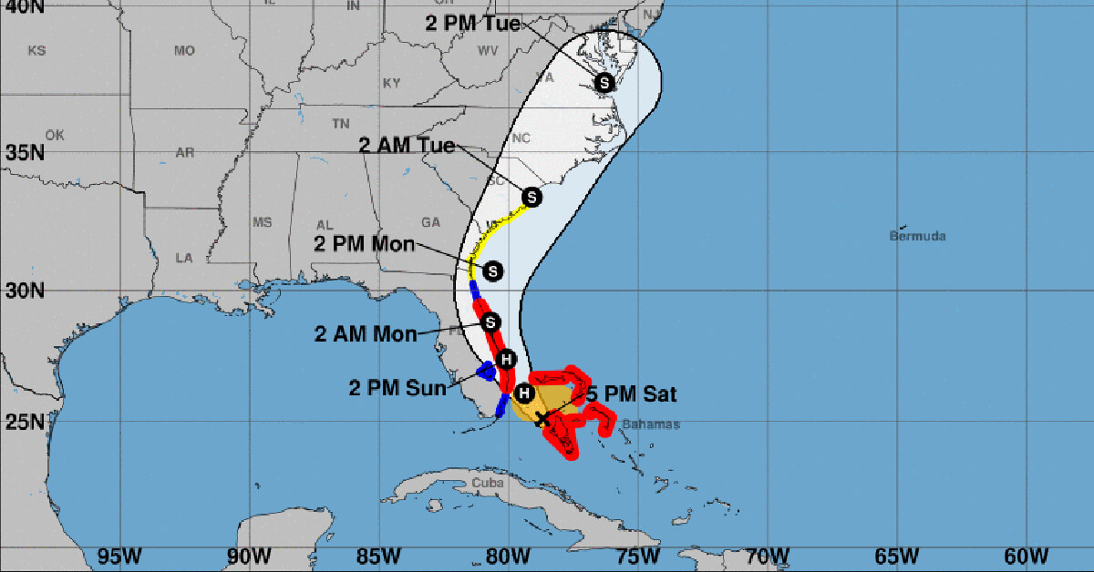
Isaias has weakened to a tropical storm, but is expected to re-strengthen to a hurricane overnight as is approaches the southeast coast of Florida. A hurricane warning is in effect for Boca Raton to the Volusia/Flagler County Line in Florida and in Northwestern Bahamas.
Operators are encouraged to check the National Hurricane Center frequently for the most up-to-date projectons.
NBAA Air Traffic Services encourages operators who are planning to travel in to affected regions to contact their FBOs and local authorities to determine what services will be available, as well as top identify off-airport issues, such as local transportation and infrastructure.
Update from the National Hurricane Center
According to the National Hurricane Center’s Advisory #19, issued at 2100z:
At 500 PM EDT (2100 UTC), the center of Tropical Storm Isaias was located by an Air Force Reserve reconnaissance aircraft near latitude 25.1 North, longitude 78.7 West. Isaias is moving toward the northwest near 10 mph (17 km/h). A general northwestward motion with some decrease in forward speed is expected for the next day or so, followed by a north-northwestward motion by late Sunday and a turn toward the north and north- northeast on Monday and Tuesday with an increase in forward speed. On the forecast track, the center of Isaias will approach the southeast coast of Florida tonight and move near or along the east coast of Florida Sunday and Sunday night. On Monday and Tuesday, the center of Isaias will move quickly from offshore of the coast of Georgia into the southern mid-Atlantic states.
Maximum sustained winds have decreased to near 70 mph (110 km/h) with higher gusts. Some restrengthening is forecast, and Isaias is expected to regain hurricane strength tonight. Slow weakening is expected to begin Sunday night and continue through Monday.
Tropical-storm-force winds extend outward up to 105 miles (165 km) from the center. During hew past couple of hours, a Weatherflow observing site at the Dania Pier in Broward County, Florida, reported a wind gust to 59 mph (94 km/h) in an outer rainband. More recently, a wind gust to 41 mph (67 km/h) was reported by a Weatherflow site in Juno Beach, Florida.
The estimated minimum central pressure based on reconnaissance aircraft data is 993 mb (29.33 inches).
Airport & Equipment Information
Airport Closures
Airports being reported closed by the FAA OIS page:
- MYNN – Closed due to ISAIAS, expected to reopen tonight at 2359z
- MYGF – Closed due to ISAIAS, expected to reopen August 4th at 1300z
Equipment Outages
The NOCC is reporting the following equipment/services outages due to ISAIAS:
- SAN JUAN, PR (SJU) ATCT ON SX DUE TO COMMERCIAL POWER FAILURE.
- GEORGETOWN, BH (FK7) ATCBI.
Protective Shutdowns
ISLANDS:
- NASSAU, BH (ZQA) ATCRB
- NASSAU, BH (MYN) ATCBI
- SAN JUAN, PR (SJU) TACAN
FLORIDA:
- MELBOURNE, FL (MLB) VOR/DME
- TITUSVILLE, FL (TIX) RWY 36 (TIX) MALSR
Route Information
There is one required route and it is basically anything leaving Florida going to the NY Metros and it is the FLORIDA_TO_NE_2_PARTIAL and is valid until 23z tonight.
Operators should also expect closures of the Atlantic Routes (ARs) between North Carolina and Florida as long as this storm follows its current forecast track.
Operational Resources
- National Hurricane Center
- FAA OIS page
- CADENA OIS page
- FAA Advisory Database
- FAA Current Reroutes
- FAA NOTAM Search
NBAA’s HERO Database
The NBAA Humanitarian Emergency Response Operator (HERO) Database is a list of people in the business aviation community who are part of disaster-response mobilization efforts. In the aftermath of major crises, basic information from the database is provided to organizations coordinating relief efforts. Learn more and register.