Updated Aug. 3, 2020 – 1230z
- Overview
- Update from the National Hurricane Center
- Airport & Equipment Information
- Route Information
- Operational Resources
- NBAA’s HERO Database
Overview
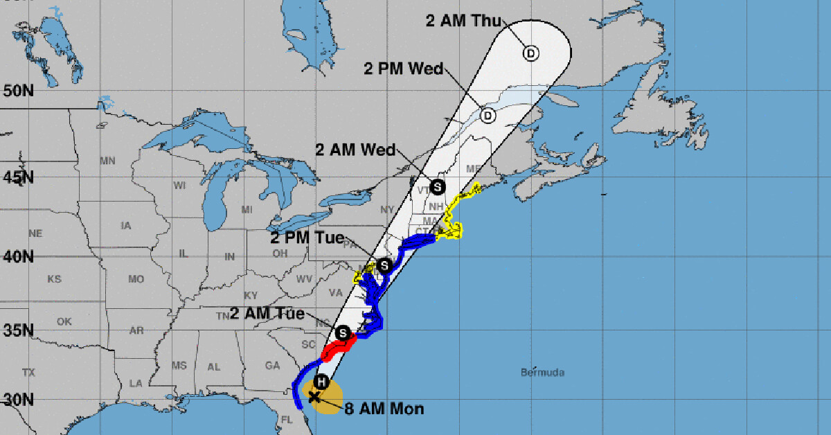
Tropical Storm Isaias is expected to increase to a Category 1 Hurricane at some point today. Currently positioned about 100 ESE of Jacksonville, FL and 240 miles southeast of Myrtle Beach, SC, it is passing east of Georgia and the south coast of South Carolina today before making landfall near North Myrtle Beach, SC and the North Carolina state line in the early morning, Tuesday. Based upon the 8AM NHC update, a swath of airports from Myrtle Beach stretching all the way up to Atlantic City have at least an 70% chance of experiencing tropical storm-force winds.
Operators are encouraged to check the National Hurricane Center frequently for the most up-to-date projectons.
NBAA Air Traffic Services encourages operators who are planning to travel in to affected regions to contact their FBOs and local authorities to determine what services will be available, as well as top identify off-airport issues, such as local transportation and infrastructure.
Update from the National Hurricane Center
According to the National Hurricane Center’s Advisory #25, issued at 1200z:
At 8 a.m. EDT (1200 UTC), the center of Tropical Storm Isaias was located by an Air Force Reserve reconnaissance aircraft and NOAA Doppler weather radars near latitude 30.2 North, longitude 80.1 West. Isaias is moving toward the north near 13 mph (20 km/h). A turn toward the north and north-northeast along with an increase in forward speed is expected later today and Tuesday. On the forecast track, the center of Isaias will pass well east of the Georgia coast through this morning. The center of Isaias will then approach the coast of northeastern South Carolina and southern North Carolina within the hurricane warning area later today. The center will then move inland over eastern North Carolina tonight, and move along the coast of the mid-Atlantic states on Tuesday and into the northeastern United States by Tuesday night.
Maximum sustained winds are near 70 mph (110 km/h) with higher gusts. Some strengthening is anticipated today, and Isaias is forecast to regain hurricane strength before it reaches the coast of northeastern South Carolina or southern North Carolina tonight. Slow weakening is forecast after Isaias makes landfall in the Carolinas and moves across the U.S. mid-Atlantic region tonight and Tuesday.
Tropical-storm-force winds extend outward up to 125 miles (205 km) from the center. During the past hour a wind gust to 40 mph (65 km/h) was observed at the St, Augustine Pier, Florida, and a sustained wind of 34 mph (55 km/h) and a gust to 40 mph (65 km/h) were measured by a Weatherflow station at the Jacksonville Beach Pier, FL.
The estimated minimum central pressure is 994 mb (29.36 inches).
Airport & Equipment Information
The following equipment/services are out of service due to the Tropical Storm Isaias:
Unscheduled
- SAN JUAN, PR (SJU) ATCT ON SX DUE TO UNSTABLE COMMERCIAL POWER.
- FT LAUDERDALE, FL (FLL) RWY 28L (ADI) GS.
Protective Shutdowns
SOUTH CAROLINA:
- Wilmington International Airport (ILM) ATCT will close early this evening
ISLANDS:
- SAN JUAN, PR (SJU) TACAN.
FLORIDA:
- MELBOURNE, FL (MLB) VOR/DME.
- TITUSVILLE, FL (TIX) RWY 36 (TIX) MALSR.
Route Information
- All AR routes (except AR3) closed.
- Florida to Northeast Route impacts are expected.
- Formal published routes from Texas, the Midwest and the West Coast to the Northeast currently under construction, the bulk of which will corral flights from these regions away from the Southeast. As the Florida to Northeast flights push inland, the entire NAS will need to shift west and north to afford room to efficiently route flights away from Jacksonville and Southern Washington center airspace.
- VHP_TO_DCMETS_PHL
- JOT_2_TO_NYMETS_BOS
- CAN_ULUTO_EAST_1_PARTIAL (Canadian Route)
Operational Resources
- National Hurricane Center
- FAA OIS page
- CADENA OIS page
- FAA Advisory Database
- FAA Current Reroutes
- FAA NOTAM Search
NBAA’s HERO Database
The NBAA Humanitarian Emergency Response Operator (HERO) Database is a list of people in the business aviation community who are part of disaster-response mobilization efforts. In the aftermath of major crises, basic information from the database is provided to organizations coordinating relief efforts. Learn more and register.