Updated Aug. 3, 2020 – 2230z
- Overview
- Update from the National Hurricane Center
- Airport & Equipment Information
- Route Information
- Operational Resources
- NBAA’s HERO Database
Overview
Tropical Storm Isaias will be packing winds of over 60 knots at the center as it makes landfall. The tropical storm force winds in excess of 34 knots may reach as far as 100 miles from the center. The counter-clockwise rotation will push dangerous storm surges inland as it comes up the coast. It will also bring flooding rains and thunderstorms that may spawn tornadoes.
Operators are encouraged to check the National Hurricane Center frequently for the most up-to-date projectons.
Operators who are planning to travel in to affected regions should contact their FBOs and local authorities to determine what services will be available, as well as top identify off-airport issues, such as local transportation and infrastructure.
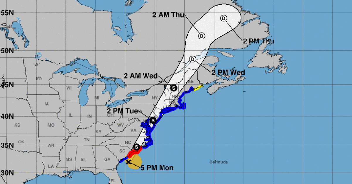
Update from the National Hurricane Center
According to the National Hurricane Center’s Advisory #27, issued at 2100z:
At 5 p.m. EDT (2100 UTC), the center of Tropical Storm Isaias was located by NOAA Doppler weather radars near latitude 32.0 North, longitude 79.4 West. Isaias is moving toward the north-northeast near 16 mph (26 km/h), and this general motion accompanied by a gradual increase in forward speed is expected through tonight followed by a further increase in the forward speed on Tuesday. On the forecast track, the center of Isaias will approach the coasts of northeastern South Carolina and southern North Carolina within the hurricane warning area this evening. The center will then move inland across eastern North Carolina early Tuesday morning, move along the coast of the mid-Atlantic states on Tuesday, and continue across the northeastern United States Tuesday night.
Data from NOAA Doppler weather radars indicate that maximum sustained winds are near 70 mph (110 km/h) with higher gusts. Some strengthening is forecast later this afternoon or early evening, and Isaias is expected to make landfall tonight at or near hurricane strength along the coast of northeastern South Carolina or southern North Carolina. Only gradual weakening is anticipated after Isaias makes landfall in the Carolinas and moves across the U.S. mid-Atlantic region tonight and Tuesday.
Tropical-storm-force winds extend outward up to 125 miles (205 km) from the center. During the past couple of hours, a sustained wind of 45 mph (72 km/h) and a gust to 52 mph (83 km/h) were measured by a Weatherflow site at Folly Beach Pier, SC.
Airport & Equipment Information
Airport information
While no airport closures are expected tomorrow, numerous traffic management initiatives may be used in order to manage the flow of traffic into the major airports from the DC metros to Boston all day tomorrow. These may include, and certainly won’t be limited to, ground stops or ground delay programs. Some of these stops may be lengthy as we are expecting very strong winds with even stronger gusts, in addition to low ceilings and reduced visibility. This may lead to significant airborne holding as terminals are impacted directly. Significant tactical deviations are also likely, as are lengthy departure delays from these areas in order to favor the airborne traffic and allow space for the deviations for departing traffic.
Equipment and Service Outages
Unscheduled
- SAN JUAN, PR (SJU) ATCT ON SX DUE TO UNSTABLE COMMERCIAL POWER
- FT LAUDERDALE, FL (FLL) RWY 28L (ADI) GS.
Scheduled Protective Shutdowns
- NONE
Route Information
Due to the passage of the storm and significant areas of convective weather associated with the storm, operators should monitor the FAA Current Reroutes page closely for required and recommended reroutes overnight and into tomorrow, especially as the storm passes through DC, Philadelphia and the NY metro areas.
Operational Resources
- National Hurricane Center
- FAA OIS page
- CADENA OIS page
- FAA Advisory Database
- FAA Current Reroutes
- FAA NOTAM Search
NBAA’s HERO Database
The NBAA Humanitarian Emergency Response Operator (HERO) Database is a list of people in the business aviation community who are part of disaster-response mobilization efforts. In the aftermath of major crises, basic information from the database is provided to organizations coordinating relief efforts. Learn more and register.