Updated Aug. 4, 2020 – 1240z
- Overview
- Update from the National Hurricane Center
- Airport & Equipment Information
- Route Information
- Operational Resources
- NBAA’s HERO Database
Overview
Tropical Storm Isaias is moving quickly up eastern Virginia with strong winds, heavy rainfall and the threat of tornadoes. The storm will continue to move quickly northbound up the Mid-Atlantic coast this morning. As the Tropical Storm continues its quick visit to the northeast, expect gusty winds, wind shifts (runway configuration issues), wind shear, heavy rains and wet runways and lowered visibilities at most of the DC, PHL, NY and BOS airports, until it passes by late afternoon/early evening. This will be the last update provided for this storm.
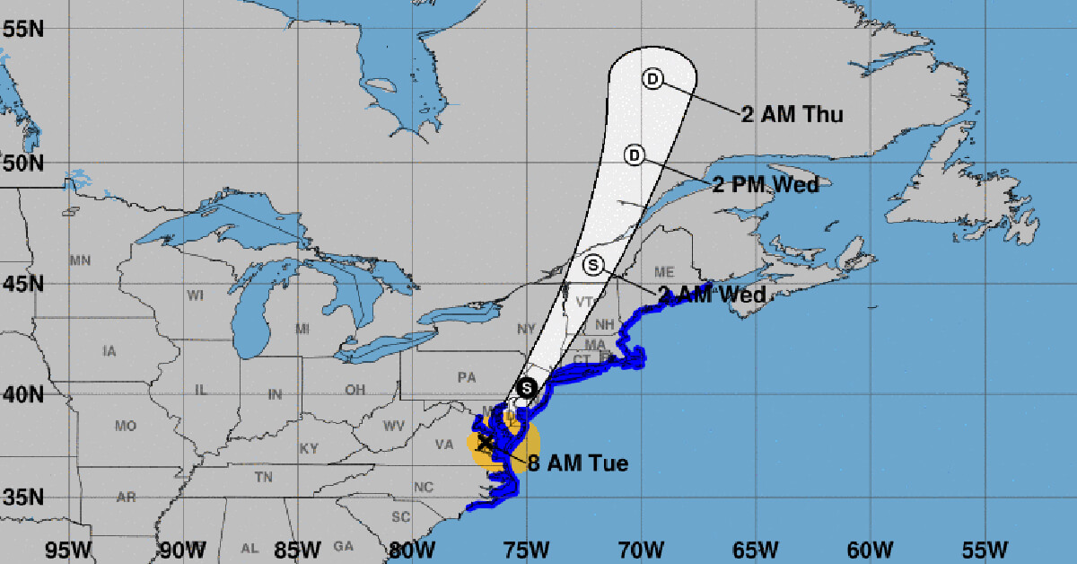
Update from the National Hurricane Center
According to the National Hurricane Center’s Advisory #29A, issued at 1200z:
At 8 a.m. EDT (1200 UTC), the center of Tropical Storm Isaias was located over southeastern Virginia near latitude 37.7 North, longitude 76.8 West. Isaias is moving toward the north-northeast near 33 mph (54 km/h), and this general motion accompanied by some additional increase in forward speed is expected through today. On the forecast track, the center of Isaias will continue to move near or along the coast of the mid-Atlantic states today, and move across the northeastern United States into southern Canada tonight.
Maximum sustained winds are near 70 mph (110 km/h) with higher gusts. Only gradual weakening is anticipated while Isaias moves north-northeastward near the mid-Atlantic coast today. A faster rate of weakening is expected to begin tonight, and the system is forecast to become post-tropical tonight or early Wednesday.
Tropical-storm-force winds extend outward up to 140 miles (220 km) from the center. Sustained winds of 63 mph (101 km/h) and a gust to 77 mph (124 km/h) were recently reported at Third Island, VA at the mouth of the Chesapeake Bay.
The estimated minimum central pressure based on surface observations is 993 mb (29.33 inches).
Airport & Equipment Information
- Norfolk International Airport (ORF) ATC Alert due to a commercial power outage, operating on generator
- FT LAUDERDALE, FL (FLL) RWY 28L (ADI) GS.
- FT FISHER, NC (QGV) ATCRB.
- MYRTLE BEACH, SC (MYR) ASR.
Route Information
There are no formal routes proposed for the Northeast at this time. There will be some temporary disruptions to all impacted airspace while the storm persists. Arrival holding, ground stops, departure delays and route amendments are all possible at all DC/PHL/NY/BOS airports when Isaias is passing through. The NY terminal area is operating in SWAP and has impacts as described below.
- AZEZU-PAEPR-HANRI (L453-Y493) IMPACTS ARE EXPECTED
- DITCH IMPACTS ARE EXPECTED
- INTERNATIONAL DEPARTURES (EAST GATES) IMPACTS ARE EXPECTED
PLANNED ALTERNATE DEPARTURE ROUTES:
- REROUTES / CDR’S WILL BE PROVIDED AS NECESSARY.
- ESCAPE ROUTES, INCLUDING SERMNS, PHLYERS, AND GREKIS, ARE
POSSIBLE. CONTINUE TO MONITOR ADVZY’S FOR UPDATES.
ADDITIONAL DEPARTURE REROUTES MAY BE POSSIBLE FOR IMPACTS TO
AFFECTED AIRWAYS OUTSIDE ZNY.
PLANNED ALTERNATE ARRIVAL ROUTES:
- POSSIBLE REROUTES / CDR’S WILL BE PROVIDED AS NECESSARY.
- TACTICAL REROUTES TO THE NY METS ARE POSSIBLE THROUGHOUT THE DAY BASED ON REAL TIME WX IMPACTS.
Operational Resources
- National Hurricane Center
- FAA OIS page
- CADENA OIS page
- FAA Advisory Database
- FAA Current Reroutes
- FAA NOTAM Search
NBAA’s HERO Database
The NBAA Humanitarian Emergency Response Operator (HERO) Database is a list of people in the business aviation community who are part of disaster-response mobilization efforts. In the aftermath of major crises, basic information from the database is provided to organizations coordinating relief efforts. Learn more and register.