Updated Nov. 10, 2022 – 2315z
- Overview
- Update from the National Hurricane Center
- Airport & Equipment Information
- Route Information
- Operational Resources
- NBAA’s HERO Database
Overview
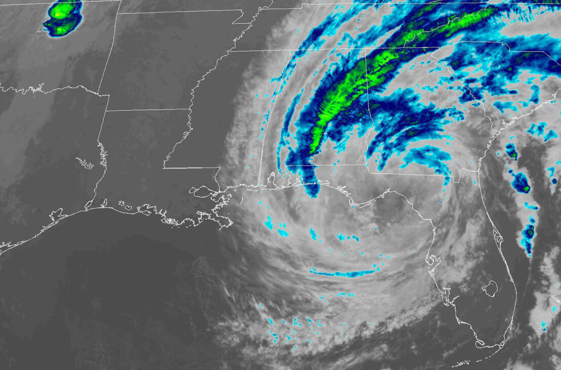
The center of Nicole briefly emerged overwater north of Tampa around 1800Z and is now straddling the coast of the Florida Big Bend region northwest of Cedar Key. An earlier scatterometer overpass showed winds of about 40 kt west of the center over the Gulf of Mexico, and this is the main basis for the initial intensity of 40 kt. Surface observations indicate that the central pressure has risen to near 990 mb. In addition to weakening, the 34-kt wind radii associated with the storm have decreased, particularly in the northeastern quadrant.
Update from the National Hurricane Center
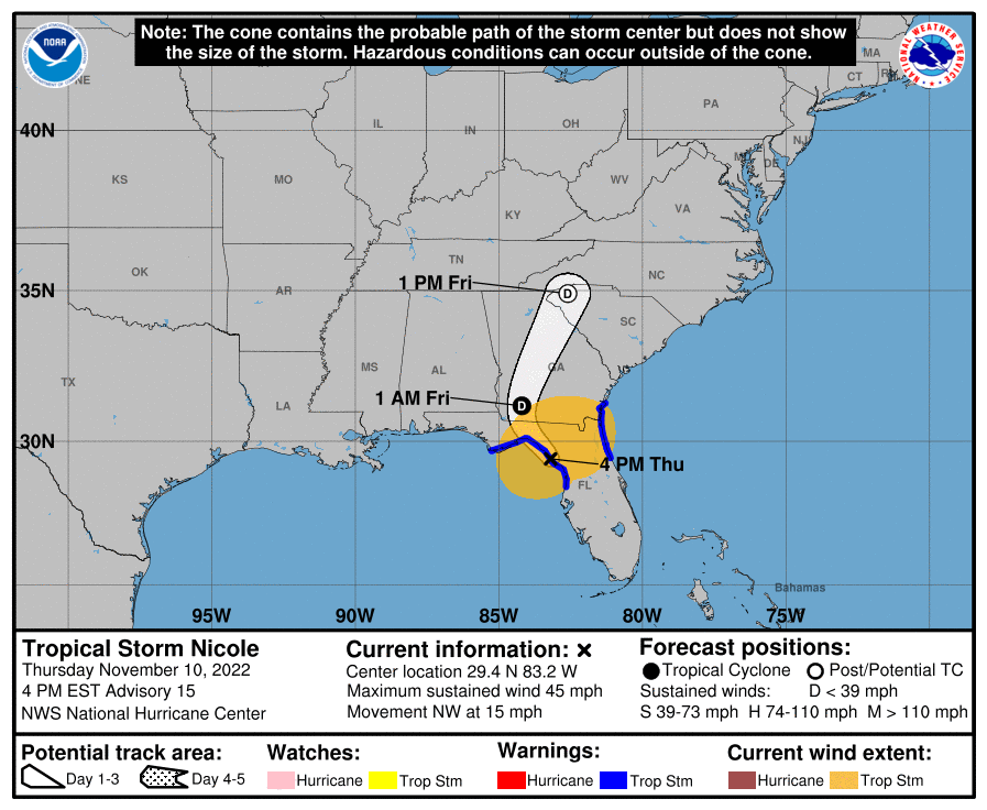
According to the National Hurricane Center’s Advisory #15, issued at 2100z:
At 400 PM EST (2100 UTC), the center of Tropical Storm Nicole was located near latitude 29.4 North, longitude 83.2 West. Nicole is moving toward the northwest near 15 mph (24 km/h), and this general motion should continue this evening, followed by a turn toward the north tonight. Nicole is expected to accelerate north-northeastward on Friday. On the forecast track, the center of Nicole will move along the coast of the Florida Big Bend region for the next several hours before moving across the eastern Florida Panhandle. After that, Nicole should move northward over Georgia later tonight, and then move through the southeastern United States on Friday.
Maximum sustained winds are near 45 mph (75 km/h) with higher gusts. These winds are mainly occurring over the Gulf of Mexico to the west of the center. Little change in strength is expected this evening while the center moves along the coast of the Florida Big Bend. Nicole is expected to weaken to a depression over Georgia tonight, and then it is expected to dissipate as it merges with a frontal boundary over the Mid-Atlantic United States by Friday night.
Tropical-storm-force winds extend outward up to 175 miles (280 km) from the center. A WeatherSTEM station on the campus of the University of Florida in Gainesville recently reported a wind gust of 54 mph (87 km/h).
The estimated minimum central pressure is 990 mb (29.24 inches). The NOAA National Ocean Service Station at Cedar Key, Florida, recently reported a pressure of 989.5 mb (29.22 inches) as the center passed nearby.
Airport & Equipment Information
Unscheduled System Failures
- ORLANDO, FL (MCOA) GBTS OTS.
- MERRITT ISLAND, FL (COI) GBTS OTS.
- OCALA, FL (OCF) VOR OTS.
Protective Shutdowns
- GAINESVILLE, FL (GNV) ASR/MODES UFN.
- ORLANDO, FL (MCO) ASDE UFN.
- ORLANDO, FL (MCO) ASR/MODES UFN.
- ORLANDO, FL (MCO) RWSL UFN.
- WHITEHOUSE, FL (NEN) NDAG UFN.
Route Information
The AR routes are still open this evening with convective activity along the routes with tops to FL340. Jacksonville Center is still recommending use of the AR routes because the coastal/central/west FL airways are constrained with thunderstorms. The deepwater WATRS Routes between the Northeast and FL are available and recommended.
Operational Resources
- National Hurricane Center
- FAA OIS page
- CADENA OIS page
- FAA Advisory Database
- FAA Current Reroutes
- FAA NOTAM Search
NBAA’s HERO Database
The NBAA Humanitarian Emergency Response Operator (HERO) Database is a list of people in the business aviation community who are part of disaster-response mobilization efforts. In the aftermath of major crises, basic information from the database is provided to organizations coordinating relief efforts. Learn more and register.