Updated Sept. 16, 2020 – 2200
- Overview
- Update from the National Hurricane Center
- Airport & Equipment Information
- Route Information
- Operational Resources
- NBAA’s HERO Database
Overview
Presently Tropical Storm Sally’s winds have now reached 60mph. The storm is located about 55 miles NNE of Pensacola, FL. Winds should start to decrease over the next several hours, but flooding continues to be an issue. Pensacola International Airport (PNS) is ATC Zero due to Tropical Storm Sally.
Update from the National Hurricane Center
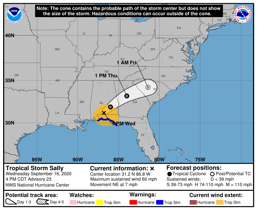
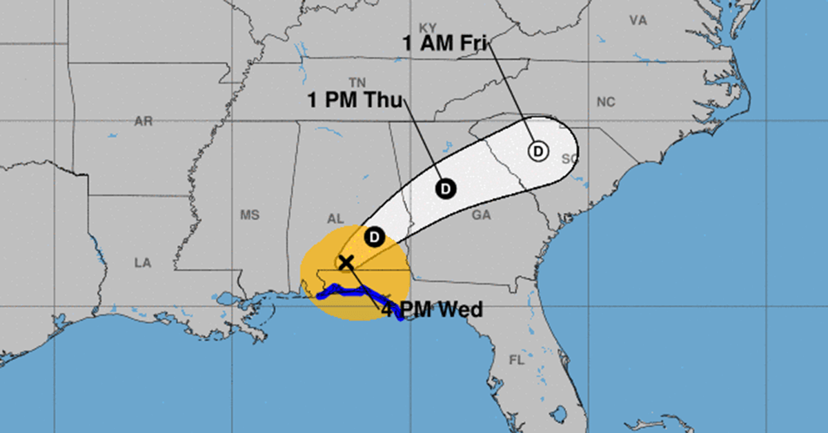
According to the National Hurricane Center’s Advisory #23, issued at 2100z:
At 400 PM CDT (2100 UTC), the center of Tropical Storm Sally was located near latitude 31.2 North, longitude 86.8 West. Sally is moving toward the northeast near 7 mph (11 km/h), and a northeastward motion at a slightly faster forward speed is expected tonight through Thursday night. On the forecast track, the center of Sally will move across southeastern Alabama tonight, over central Georgia on Thursday, and move over South Carolina Thursday night.
Maximum sustained winds have decreased to near 60 mph (95 km/h) with higher gusts. Additional weakening is expected as the center moves farther inland tonight, and Sally is forecast to become a tropical depression tonight or Thursday morning.
Tropical-storm-force winds extend outward up to 125 miles (205 km) from the center.
The estimated minimum central pressure is 990 mb (29.23 inches).
Airport & Equipment Information
Airport closures from the FAA OIS page:
- 0R1 – closed
- 4R9 – closed – scheduled to reopen 9/17 at 18z
- CEW – closed – scheduled to reopen 9/17 at 17z
- DTS – closed – scheduled to reopen 9/17 at 17z
- PNS – closed to fixed wing aircraft – scheduled to reopen 9/16 at 21z
Route Information
There are no current Hurricane Routes published.
Operational Resources
- National Hurricane Center
- FAA OIS page
- CADENA OIS page
- FAA Advisory Database
- FAA Current Reroutes
- FAA NOTAM Search
NBAA’s HERO Database
The NBAA Humanitarian Emergency Response Operator (HERO) Database is a list of people in the business aviation community who are part of disaster-response mobilization efforts. In the aftermath of major crises, basic information from the database is provided to organizations coordinating relief efforts. Learn more and register.