Updated Sept. 5, 2019 – 1830z
- Overview
- Update from the National Hurricane Center
- Airport & Equipment Information
- Route Information
- Bahamas Relief Supplies
- NBAA’s HERO Database
Overview
Hurricane Dorian continues to make its way along the southeast coast, now just off the South Carolina coast, on its way to being a good distance off the Virginia coast by Friday morning. Most of the impacts at this point are airport closures in the Carolinas and route impacts for traffic to and from Florida. A few takeaways:
- Most Florida airports are now open and normal ops.
- There are some airport closures along the South Carolina and North Carolina coasts, including places like HXD, ILM and FLO.
- Traffic to and from Florida is being routed to the west over inland routes to keep it clear of Dorian.
An airspace flow program (AFP) in place for traffic to MYNN to help manage the high volume into that airport.
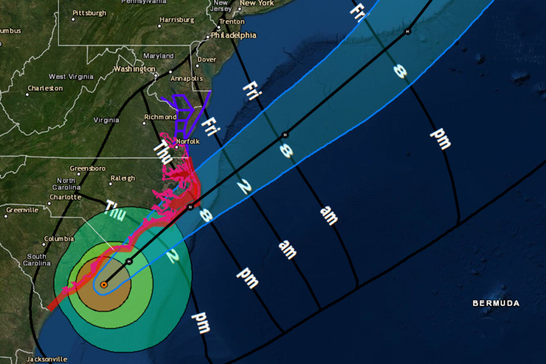
Update from the National Hurricane Center
According to the National Hurricane Center’s Advisory 49A#, issued at 1800z:
At 200 PM EDT (1800 UTC), the center of Hurricane Dorian was located near latitude 32.8 North, longitude 78.9 West. Dorian is moving toward the north-northeast near 8 mph (13 km/h). A turn toward the northeast is anticipated by tonight, and a northeastward motion at a faster forward speed is forecast on Friday. On the forecast track, the center of Dorian will continue to move close to the coast of South Carolina this afternoon, and then move near or over the coast of North Carolina tonight and Friday. The center should move to the southeast of extreme southeastern New England Friday night and Saturday morning, and approach Nova Scotia later on Saturday.
Reports from an Air Force Reserve Hurricane Hunter aircraft indicate that maximum sustained winds are near 110 mph (175 km/h) with higher gusts. Slow weakening is expected during the next few days. However, Dorian is expected to remain a powerful hurricane as the center moves near the coasts of South and North Carolina.
Hurricane-force winds extend outward up to 60 miles (95 km) from the center and tropical-storm-force winds extend outward up to 195 miles (315 km). The Weatherflow station at Winyah Bay, South Carolina, recently reported sustained winds of 77 mph (124 km/h) and a wind gust of 85 mph (137 km/h). A buoy operated by the Coastal Ocean Research and Monitoring Program 15 miles northeast of the entrance to Charleston Harbor recently reported a wind gust of
92 mph (148 km/h).
The minimum central pressure based on Hurricane Hunter aircraft and buoy data is 958 mb (28.29 inches). NOAA buoy 41004 reported a minimum pressure of 959.4 mb (28.33 inches) as the eye passed over it.
Airport & Equipment Information
Bahamas Airports
Bahamas Airports – check NOTAMs for current status.
U.S. Airports
- CHS – OPEN, BUT NO TERMINAL ATC SERVICES AVAILABLE
- FLO – CLOSED EXCEPT PPR AIRCRAFT
- HXD – CLOSED
- ILM – BEGINNING 09050100 AD AP CLOSED TO COMMERCIAL AIRCRAFT
- NBC – CLOSED
Protective Shutdowns
Florida
- DAYTONA BEACH, FL (DAB) RWY 07L (DAB) MALSR.
- DAYTONA BEACH, FL (DAB) RWY 25R (DBF) MALSR.
- FT LAUDERDALE, FL (FXE) RWY 09 (FXE) MALSR.
- FT LAUDERDALE, FL (FLL) ASDE.
- JACKSONVILLE, FL (NIP) ASR.
- ORLANDO, FL (F11) RTR.
- ORMOND BEACH, FL (OMN) VOR/TACAN/RCO.
- POMPANO BEACH, FL (PMP) RWY 15 (PMP) MALS.
- SANFORD, FL (SFB) RWY 27R (FNU) MALSR.
- SANFORD, FL (SFB) RWY 09R (OOS) MALSR.
- SANFORD, FL (SFB) RWY 09L (SND) MALSR.
Carolinas
- CHARLESTON, SC (CHS) ASR/MODES.
- CHARLESTON, SC (CHS) RWY 15 (CHS) LOC/GS.
- MYRTLE BEACH, SC (MYR) ASR/ATCRB.
- WILMINGTON, NC (ILM) ASR/MODES.
Unscheduled Outages
- MELBOURNE, FL (MLB) RVR.
- GRAND BAHAMA, BH (BHF) ATCBI.
- GRAND BAHAMA, BH (BHF) RCAG (132.95/123.675/134.2/363.05 MHZ).
- GRAND BAHAMA, BH (BHF) RCO (126.9 MHZ).
- SOUTH BIMINI, BH (ZBV) RCO. VOR UNMONITORED.
Operators with questions can contact the ATCSCC National Operations Control Center (NOCC) at 540-359-3110.
Route Information
Miami Center (ZMA) and Jacksonville Center (ZJX) are normal operations at this time.
Required Reroutes
- NE_TO_FLORIDA_VIA_J48_1_MODIFIED – taking southbound traffic from the northeast through Atlanta Center and down the west coast of FL
- MIDWEST_TO_SOUTH_FL – taking southbound traffic from the Midwest and northeast down the west coast of FL to FLL/MIA/PBI
- AZEZU – optional route to allow traffic to fly over the Atlantic east of Dorian
- WEST_TO_FLORIDA – taking traffic from the western US over CEW down the west coast of FL to southern FL airports
- FLORIDA_TO_NE_2_PARTIAL – taking northbound traffic from FL through Atlanta Center to the northeast
Operational Resources
- National Hurricane Center
- FAA OIS page
- CADENA OIS page
- FAA Advisory Database
- FAA Current Reroutes
- FAA NOTAM Search
Bahamas Relief Supplies
The South Florida Business Aviation Association (SFBAA) and others in the business aviation community are collecting supplies in support of relief efforts in the Bahamas.
There are multiple drop-off locations in southern Florida. If you would like your facility or office to be added as a drop-off location, or if you are interested in having your facility added as a staging area for relief flights, please email scott@ramjetaviation.com.
SFBAA reports that FBOs in South Florida are willing to waive fees and provide fuel discounts to those interested in participating in relief flights.
Drop-off Locations
Signature FBO, PBI
1500 Perimeter Rd.
West Palm Beach, FL 33406
Signature is accepting items that will be delivered via Cherokee Air Limited. Contact Jose.cabrera@signatureflight.com or 561-683-5939 for questions.
Signature FBO, BCT
3300 Airport Rd
Boca Raton, FL 33431
Signature will be accepting donated. Fuel discounts and clearing fee waivers will be available for all aircraft participating in relief flights. For more information, contact garry.madolid@signatureflight.com or 561-955-9556
Banyan Air Service, FXE
5360 NW 20th Terrace
Fort Lauderdale, FL 33309
Front Desk: 954-491-3170
Contact: Isadora or Giselle
Email helpinghands@banyanair.com with regards to Bahamas relief efforts.
In cooperation with the Bahamas National Emergency Management Agency (NEMA) through the Bahamas Tourist and Aviation Office, Banyan Air Service will be using Hangar 9 (attached to the Jet Café) to label and store cargo that will be airlifted to the Bahamas. Banyan will have forklifts and manpower to assist.
Gold Aviation, FLL
1420 Lee Wagener Blvd
Fort Lauderdale, FL 33315
Gold Aviation will be accepting donations and will be managing relief flights to and from the Bahamas. If you are interested in donating your aircraft or pilot services, please reach out to the Gold Aviation Team at charter@goldaviation.com or 954-359-9919.
Jetscape Alpha FBO Hangar, FLL
350 SW 34th Street
Ft. Lauderdale, FL 33315
Jetscape will be accepting donations and will be managing relief flights to and from the Bahamas. For more information, contact 954-359-9991 or customerservice@jetscapefbo.com.
Relief Supplies Most Needed
- Water (all sizes – small and large 1 & 5 gallon)
- Deodorant (men & women)
- Shampoo
- Clothing detergent
- Bug spray
- Sunscreen
- Chapstick
- Pull-tab canned goods (soup, vegetables, meat)
- Plastic jars of tomato sauce
- Breakfast foods (Pop Tarts, granola bars)
- Individual cereal boxes
- Manual can openers
FOOD (Non-perishable Items)
Pull-Tab Can Goods (Soup, Vegetables, Meat), Breakfast (Dry Cereal, Pop Tarts, Granola Bars), Peanut Butter, 100% Fruit Juice, Sports Drinks, Individual Snacks (Crackers, Rice Krispies), Individual Fruit (Fruit Cup, Applesauce)
CLEANING SUPPLIES
Bleach, Disinfectant, Mops, Buckets, Rubber / Plastic Gloves, Sponges, Brooms, Trash Bags (Kitchen, Large Heavy Duty)
BABY SUPPLIES
Diapers (All Sizes), Baby Wipes, Baby Formula, Baby Food
HYGIENE KITS
Towels, Wash Cloths, Razor, Shaving Cream, Body Wash, Bar Soap, Shampoo, Feminine Products, Toothbrush, Toothpaste, Mouthwash, Hand Sanitizer, Hand Soap, Deodorant
MEDICAL SUPPLIES
First Aid Kits, Non-Prescription Drugs, Band-Aids, Medical Tape, Ointments, Disinfectant Spray or Wipes, Eye Drops, Chapstick, Sunscreen, Bug Spray.
BEDDING
Blankets, Sheets, Pillows, Sleeping Bags, Cots
CLOTHING
Underwear (All Sizes), Socks (All Sizes)
PAPER SUPPLIES
Plates, Bowls, Cups, Paper Towels, Toilet Paper, Pre-Wrapped Flatware, Plastic Bags (Storage, Gallon)
PET SUPPLIES
Dry Food, Canned Food
OTHER ITEMS
- Portable generators
- Hurricane shutters
- Emergency ladders
- Batteries, single or multipack (AAA cell, AA cell, C cell, D cell, 6 volt or 9 volt)
- First aid kits
- Fuel containers
- Ground anchor systems and tie-down kits
- Machetes
- Axes and chainsaws
- Mobile telephone batteries and mobile telephone chargers
- Non-electric coolers and ice chests for food storage
- Non-electric can openers
- Portable self-powered light sources (hand cranked flashlights)
- Portable self-powered radios, including two-way and weather band radios
- Reusable and artificial ice products
- Smoke detectors, fire extinguishers and carbon monoxide detectors
- Tarps and other plastic sheeting
- Tools – Drills, Wheelbarrows, Buckets, Hammers, Screwdrivers, etc.
- Heavy Duty Trash Bags
- Face Masks
- Construction gloves
- Solar lights
- Duct tape
- Extension Cords / Power strips
NBAA’s HERO Database
The NBAA Humanitarian Emergency Response Operator (HERO) Database is a list of people in the business aviation community who are part of disaster-response mobilization efforts. In the aftermath of major crises, basic information from the database is provided to organizations coordinating relief efforts. Learn more and register.