Updated Sept. 6, 2019 – 1330z
- Overview
- Update from the National Hurricane Center
- Airport & Equipment Information
- Route Information
- Operational Resources
- Dorian Relief Efforts for the Bahamas
- NBAA’s HERO Database
Overview
Dorian is now off the North Carolina coast and will move fairly quickly up off the Virgnia coast today, weakening as it moves further north toward New England over the weekend. A few takeaways:
- Most North Carolina coastal airports should be open by 1600z today, except for Oceana NAS (NTU). Additional airport closures are not expected.
- Traffic between the northeast and Florida is again today being routed to the west, over inland routes to keep it clear of the effects of Dorian.
- An airspace flow program (AFP) may be used again today to manage the volume heading into MYNN, though volume appears to be lower today, so it may not be necessary.
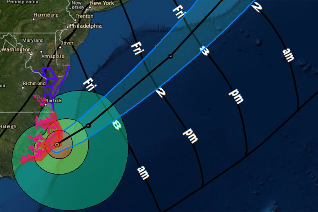
Update from the National Hurricane Center
According to the National Hurricane Center’s Advisory #52A, issued at 1200z:
At 800 AM EDT (1200 UTC), the center of Hurricane Dorian was located near latitude 35.2 North, longitude 75.7 West. Dorian is moving toward the northeast near 14 mph (22 km/h) and this general motion with an increase in forward speed is expected through Saturday. On the forecast track, the center of Dorian will move near or over the coast of North Carolina during the next few hours. The center should move to the southeast of extreme southeastern New England tonight and Saturday morning, and then across Nova Scotia late Saturday or Saturday night.
Maximum sustained winds are near 90 mph (150 km/h) with higher gusts. Dorian should remain a powerful hurricane as it moves near or along the coast of North Carolina during the next few hours. Dorian is forecast to become a post-tropical cyclone with hurricane-force winds by Saturday night as it approaches Nova Scotia.
Hurricane-force winds extend outward up to 45 miles (75 km) from the center and tropical-storm-force winds extend outward up to 220 miles (350 km). A Weatherflow station at Buxton, North Carolina, recently reported a sustained wind of 67 mph (107 km/h) and a gust to 85 mph (145 km/h).
The estimated minimum central pressure based on data from the Air Force Hurricane Hunters and surface observations is 956 mb (28.23 inches). An automated station in Ocracoke recently reported a pressure of 960.4 mb (28.36 inches).
Airport & Equipment Information
Airport Impacts
- CHS – open, but ATC services are limited
- EWN – expected to be open by 16z and normal ops by 19z today
- NBC – expected to be open by 14z
- OAJ – expected to be open by 14z and normal ops by 16z today
- NTU – closed, expected to reopen at 16z on 9/9
- BAHAMA AIRPORTS – CHECK NOTAMS FOR CLOSURES
Protective Shutdowns
Carolinas
- CHARLESTON, SC (CHS) ASR/MODES.
- CHARLESTON, SC (CHS) RWY 15 (CHS) LOC/GS.
- MYRTLE BEACH, SC (MYR) ASR/ATCRB.
- WILMINGTON, NC (ILM) ASR/MODES.
Florida
- JACKSONVILLE, FL (NIP) ASR.
Unscheduled Outages
Florida
- MELBOURNE, FL (MLB) RVR.
Carolinas
- NORTH MYRTLE BEACH, NC (CRE) VOR UNMONITORED
- KINSTON, NC (ISO) VOR UNMONITORED
Bahamas
- GRAND BAHAMA, BH (BHF) ATCBI.
- GRAND BAHAMA, BH (BHF) RCAG (132.95/123.675/134.2/363.05 MHZ).
- GRAND BAHAMA, BH (BHF) RCO (126.9 MHZ).
- SOUTH BIMINI, BH (ZBV) RCO. VOR UNMONITORED
Operators with questions can contact the ATCSCC National Operations Control Center (NOCC) at 540-359-3110.
Route Information
Required Routes
- FLORIDA_TO_NE_1_PARTIAL – for northbound traffic from FL to the northeast
- NE_TO_FLORIDA_VIA_J75_1_PARTIAL – for southbound traffic from the northeast to FL via J75
- NE_TO_FLORIDA_VIA_J6 – for southbound traffic from the northeast to FL via J6
- NE_TO_FLORIDA_VIA_J48_1_PARTIAL – for southbound traffic from the northeast to FL via J48
Operators should review the FAA Current Reroutes page for up-to-date information.
Operational Resources
- National Hurricane Center
- FAA OIS page
- CADENA OIS page
- FAA Advisory Database
- FAA Current Reroutes
- FAA NOTAM Search
Dorian Relief Efforts for the Bahamas
The South Florida Business Aviation Association (SFBAA) and others in the business aviation community are collecting supplies in support of relief efforts in the Bahamas. Learn more about what supplies are needed and how you can help.
NBAA’s HERO Database
The NBAA Humanitarian Emergency Response Operator (HERO) Database is a list of people in the business aviation community who are part of disaster-response mobilization efforts. In the aftermath of major crises, basic information from the database is provided to organizations coordinating relief efforts. Learn more and register.