Updated Sept. 1, 2019 – 2230z
According to the National Hurricane Center’s Advisory #34, issued at 2100z:
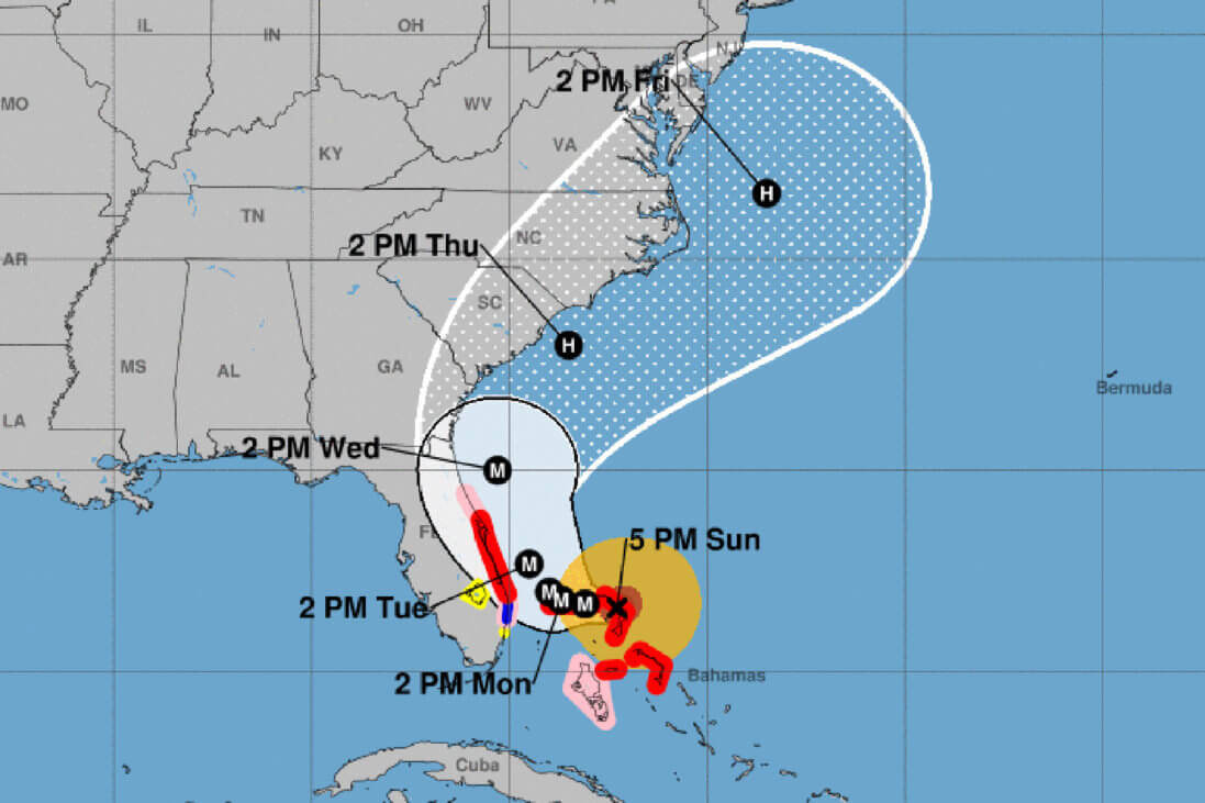
At 500 PM EDT (2100 UTC), the distinct eye of Hurricane Dorian was located near latitude 26.6 North, longitude 77.3 West. Dorian is moving toward the west near 5 mph (7 km/h). A slower westward to west-northwestward motions should continue for the next day or two, followed by a gradual turn toward the northwest. On this track, the core of extremely dangerous Hurricane Dorian will continue to pound Great Abaco this evening and move near or over Grand Bahama Island tonight and Monday. The hurricane will move dangerously close to the Florida east coast late Monday through Tuesday night.
Maximum sustained winds are near 185 mph (295 km/h) with higher gusts. Dorian is a category 5 hurricane on the Saffir-Simpson Hurricane Wind Scale. Some fluctuations in intensity are likely, and Dorian is expected to remain a catastrophic hurricane during the next few days.
Hurricane-force winds extend outward up to 45 miles (75 km) from the center and tropical-storm-force winds extend outward up to 140 miles (220 km).
The last minimum central pressure measured by an Air Force reconnaissance plane a couple of hours ago was 910 mb (26.88 inches).
Airport & Equipment Information
Airport Impacts
Please note that several airports are still determining of when or if they will close. If an airport is not listed below, it is likely the decision has not yet been made. NBAA Air Traffic Services hopes to have more information by tomorrow morning’s hurricane telcon at the FAA Air Traffic Control System Command Center (ATCSCC).
- BAHAMA AIRPORTS – CHECK NOTAMS FOR CLOSURES
- MBPV – NORMAL OPS
- MYGF – CLOSED VIA NOTAM UNTIL 9/3. CHECK NOTAM FOR UPDATES.
- MYAM AND ALL OTHER IN ABACOS – CLOSED VIA NOTAM UNTIL 9/3. CHECK NOTAM FOR UPDATES.
- MCO – EXPECTED TO REMAIN OPEN AT THIS TIME AND PLANNING NORMAL OPERATIONS ON 9/2. OPERATIONS FOR 9/3 WILL BE DETERMINED ON 9/2.
- FLL / PBI – PLANS BEING MADE AT THIS TIME FOR HURRICANE OPERATIONS. WILL UPDATE NEXT TELCON.
- MLB – CLOSED TO AIR CARRIERS UNTIL 9/6 AT 2359Z
- VRB – CLOSED TO SCHEDULED AIR CARRIERS UNTIL 9/5 AT 1100Z
NBAA Air Traffic Services is also getting reports of some FBO closures in eastern Florida FBOs. If heading to Florida, be sure to make advance arrangements with your FBO to verify services.
There are now airspace coordination area (ACA) NOTAMs in place for both Jacksonville Center (ZJX) and Miami Center (ZMA) – 9/1735 (ZJX) and 09/1722 (ZMA). These NOTAMs are advisory in nature and encourage pilots to “exercise extreme caution while operating in these areas due to ongoing current rescue operations.”
Protective Shutdowns
- ANDROS ISLAND, BH (MYAF) ECOM 134.8/298.9 MHZ. ANTENNA STOWED.
- DAYTONA BEACH, FL (DAB) RWY 07L (DAB) MALSR.
- DAYTONA BEACH, FL (DAB) RWY 25R (DBF) MALSR.
- KISSIMMEE, FL (ISM) RWY 15 (ISM) LOC/GS/DME.
- SANFORD, FL (SFB) RWY 27R (FNU) MALSR.
- SANFORD, FL (SFB) RWY 09R (OOS) MALSR.
- SANFORD, FL (SFB) RWY 09L (SND) MALSR.
- TITUSVILLE, FL (TIX) RWY 36 (TIX) MALSR.
Operators with questions can contact the ATCSCC National Operations Control Center (NOCC) at 540-359-3110.
Route Information
- ZNY ADVISES THAT L454 IS OPEN. L451 / L452 / L455 REMAIN CLOSED DUE TO THUNDERSTORMS. USERS SHOULD FILE ALTERNATE ROUTES./li>