Updated Sept. 3, 2019 – 1330z
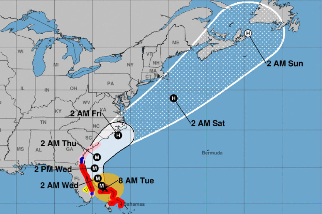
Hurricane Dorian is located approximately 110 mi ENE of West Palm Beach, FL, and has remained mostly stationary for the last day. There are indications of some slow motion now in the northwest direction.
According to the National Hurricane Center’s Advisory #40A, issued at 1200z:
At 800 AM EDT (1200 UTC), the eye of Hurricane Dorian was located by reconnaissance aircraft and NOAA Doppler radar near latitude 27.1 North, longitude 78.4 West. Dorian is beginning to move northwestward at about 1 mph (2 km/h), and a slightly faster motion toward the northwest or north-northwest is expected later today and tonight. A turn toward the north is forecast by Wednesday evening, followed by a turn to the north-northeast Thursday morning. On this track, the core of extremely dangerous Hurricane Dorian will gradually move north of Grand Bahama Island through this evening. The hurricane will then move dangerously close to the Florida east coast late today through Wednesday evening, very near the Georgia and South Carolina coasts Wednesday night and Thursday, and near or over the North Carolina coast late Thursday.
Maximum sustained winds are near 120 mph (195 km/h) with higher gusts. Dorian is a category 3 hurricane on the Saffir-Simpson Hurricane Wind Scale. Dorian is expected to remain a powerful hurricane during the next couple of days.
Hurricane-force winds extend outward up to 45 miles (75 km) from the center, and tropical-storm-force winds extend outward up to 160 miles (260 km).
The latest minimum central pressure reported by reconnaissance aircraft is 952 mb (28.11 inches).
Airport & Equipment Information
Airport Impacts
- BAHAMA AIRPORTS – CHECK NOTAMS FOR CLOSURES
- MCO – HURRICANE DORIAN EXC EMERG ACFT AND NIL OPS AND FERRY 4 HR
- PPR
- FLL – HURRICANE DORIAN
- PBI – CLOSED TO AIR CARRIERS / FBO CLOSED
- DAB – HURRICANE DORIAN / AIR CARRIER RAMP CLOSED ONLY
Equipment
Protective Shutdowns
SEE ALSO ADVZY 046
- ANDROS ISLAND, BH (MYAF) ECOM 134.8/298.9 MHZ. ANTENNA STOWED.
- DAYTONA BEACH, FL (DAB) RWY 07L (DAB) MALSR.
- DAYTONA BEACH, FL (DAB) RWY 25R (DBF) MALSR.
- FT. LAUDERDALE, FL (FXE) RWY 09 (FXE) MALSR.
- FT. LAUDERDALE, FL (FXE) RWY 09 (FXE) LOC/GS.
- FT. LAUDERDALE, FL (FLL) RWY 10R/28L (FLL/ADI) LOC/GS/MALSF.
- FT. LAUDERDALE, FL (FLL) ASDE.
- FT. LAUDERDALE, FL (FLL) ASR.
- FT. LAUDERDALE, FL (FLL) RVR.
- KISSIMMEE, FL (ISM) RWY 15 (ISM) LOC/GS/DME.
- MELBOURNE, FL (MLB) ASR/ATCRB.
- MELBOURNE, FL (MLB) ASR/MODES.
- MELBOURNE, FL (MLB) RCO.
- MELBOURNE, FL (MLB) VOR/DME.
- ORLANDO, FL (F11) RTR.
- ORLANDO, FL (ORL) VOR/TACAN.
- ORLANDO, FL (ORL) RCO.
- ORLANDO, FL (ORL) RTR.
- ORMOND BEACH, FL (ORM) VOR/TACAN/FCOM.
- PALM BEACH, FL (PBI) ASR/TSEC.
- POMPANO BEACH, FL (PMP) RWY 15 (PMP) LOC/GS/MALS.
- SANFORD, FL (SFB) RWY 27R (FNU) MALSR.
- SANFORD, FL (SFB) RWY 09R (OOS) MALSR.
- SANFORD, FL (SFB) RWY 09L (SND) MALSR.
- TITUSVILLE, FL (TIX) RWY 36 (TIX) MALSR.
- VERO BEACH, FL (VRB) ASR/MODES.
Unscheduled Outages
- GRAND BAHAMA, BH (BHF) ATCRB.
- GRAND BAHAMA, BH (BHF) RCAG (132.95/123.675/134.2/363.05 MHZ).
Operators with questions can contact the ATCSCC National Operations Control Center (NOCC) at 540-359-3110.
Route Information
0100 -MIDWEST_TO_SOUTH_FL
0100 -FCA009:NE_TO_FLORIDA_VIA_J121_2_PARTIAL
0100 -FCA010:NE_TO_FLORIDA_VIA_J75_2_PARTIAL
0100 -FCAOVR:FLORIDA_OVERFLIGHT_ROUTE
- ZMA IS NOW IN HURRICANE STAFFING.
- ZJX IS NOW IN HURRICANE STAFFING.
This will result in reduced services and increased delay for anyone in this airspace after these times.
There are no required reroutes, but operators should check the FAA Current Reroutes page for up-to-date information regarding routes.