Updated Sept. 30, 2022 – 1230z
- Overview
- Update from the National Hurricane Center
- Airport & Equipment Information
- Route Information
- Operational Resources
- NBAA’s HERO Database
Overview
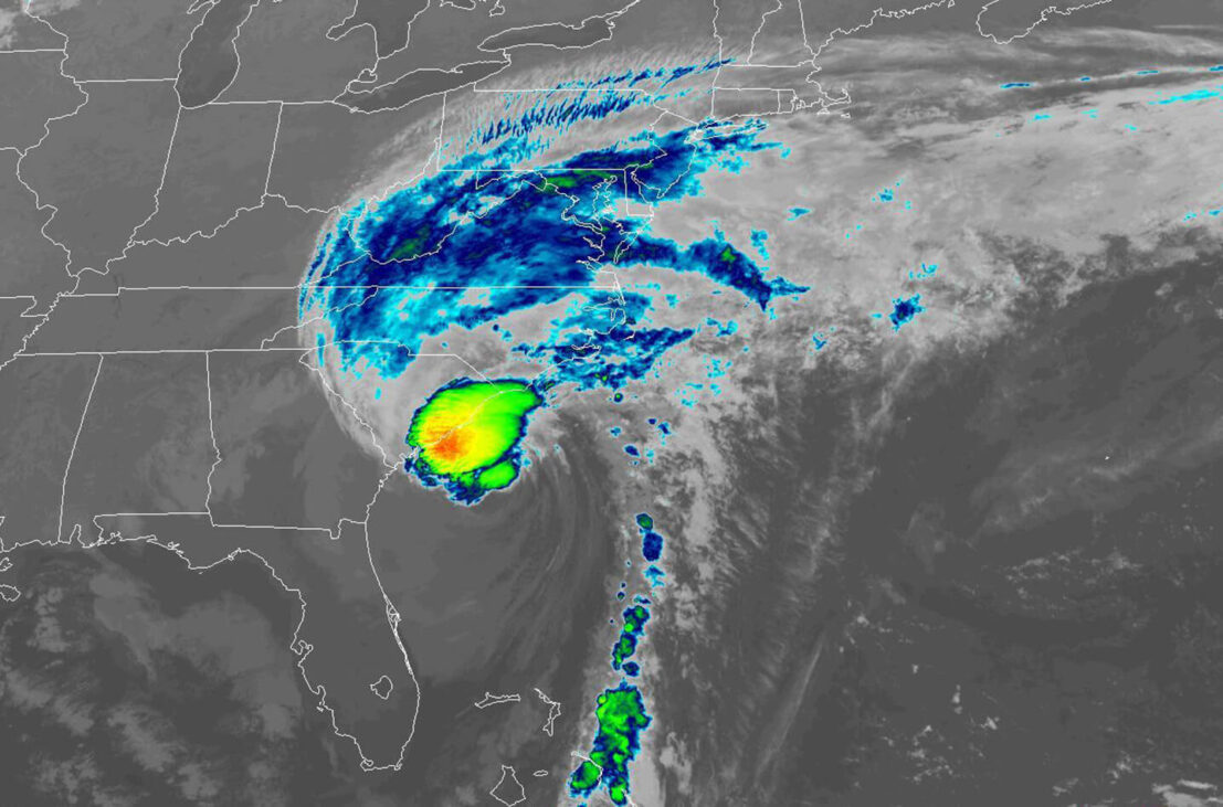
Hurricane Ian was located 105 miles south-southeast of Charleston, SC at 0800 EDT this morning with maximum sustained winds of 85 mph. Landfall this afternoon is expected somewhere between Myrtle Beach and Charleston, SC. There is already widespread rain, convective activity and tropical storm force winds across a good portion of eastern South Carolina and North Carolina. Heavy rain and wind gusts over 40 knots are expected at Charlotte Intl (CLT) after 1800z this afternoon. Rapid weakening is expected after landfall, and Ian is forecast to become an extratropical low over North Carolina tonight or on Saturday. The low is then expected to dissipate by Saturday night. Rain and wind is forecast to reach the DC Metros after 2200z later today. Flash floods are possible across portions of NC/SC/VA as the day progresses.
The recovery and search and rescue operations continue across southwest and central Florida. Numerous airports are open only to emergency and military operations. There are other airports that require prior permission (PPR) before arrival. These details are available in the NOTAMs, which remain the best source of information for airport availability and restrictions.
Update from the National Hurricane Center
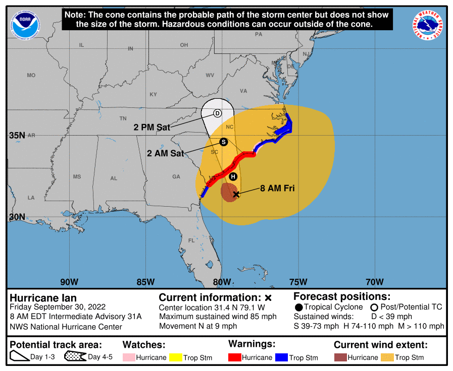
According to the National Hurricane Center’s Advisory #31A, issued at 1200z:
At 800 AM EDT (1200 UTC), the center of Hurricane Ian was located near latitude 31.4 North, longitude 79.1 West. Ian is moving toward the north near 9 mph (15 km/h). This general motion with an increase in forward speed is expected this morning, followed by a turn toward the north-northwest by tonight. On the forecast track, the center of Ian will approach and reach the coast of South Carolina today, and then move farther inland across eastern South Carolina and central North Carolina tonight and Saturday.
Maximum sustained winds remain near 85 mph (140 km/h) with higher gusts. Little change in strength is expected before Ian reaches the coast later today. Rapid weakening is expected after landfall, and Ian is forecast to become an extratropical low over North Carolina tonight or on Saturday. The low is then expected to dissipate by Saturday night.
Hurricane-force winds extend outward up to 70 miles (110 km) from the center and tropical-storm-force winds extend outward up to 485 miles (780 km). A sustained wind of 40 mph (65 km/h) and a gust to 58 mph (93 km/h) were recently reported at a WeatherFlow station on Fort Sumter Range Front Light in South Carolina.
The estimated minimum central pressure is 984 mb (29.06 inches).
Airport & Equipment Information
Airport Closures
- DAB – closed except for military and humanitarian flights until 10052200
- MCO – closed except for military and emergency related flights until 09301600 – 2 hour PPR required via phone 407-825-1681
- RSW – closed except for humanitarian flights until 10071600 – 30 minute PPR required via phone 239-590-4460
- FMY – open to humanitarian flights only until 10011600
- APF – 2 hour PPR required via phone 239-564-1692 until 10032300 – airport closed at night (sunset to sunrise) until Oct 04
- ORL – closed except for military and emergency operations until 09301600 – 2 hour PPR required via phone 407-825-1681
Unscheduled System Failures
- COW CREEK, FL (QNC) BUECS OTS.
- DAYTONA BEACH, FL (DAB) GBTS OTS.
- FT GREEN, FL (FN7) ARSR (RDAT/BDAT) OTS.
- KEY WEST, FL (EYW) GBTS OTS.
- KEY WEST, FL (EYW) BUEC OTS.
- LABELLE, FL (LBV) BUEC OTS.
- MIAMI, FL (MIA) RWY 26L (VIN) GS OTS.
- OKEECHOBEE, FL (OBE) GBTS OTS.
- SANFORD, FL (SFB) RWY 09R (OOS) LOC OTS.
- SARASOTA, FL (X06) GBTS OTS.
- ST. AUGUSTINE (SGJ) BUEC OTS.
- ST. AUGUSTINE (SGJ) FDIO OTS.
Protective Shutdowns
- COCOA BEACH, FL XMR FDAT UFN.
- DAYTONA BEACH, FL (DAB) ASR UFN.
- DAYTONA BEACH, FL (DAB) MODES UFN.
- FT MYERS, FL (FMY) RVR UFN.
- FT MYERS, FL (FMY) RWY 05 (RSW) LOC UFN.
- FT MYERS, FL (FMY) RWY 05 (RSW) GS UFN.
- FT MYERS, FL (FMY) RWY 06 (RSW) MALSR UFN.
- FT MYERS, FL (RSWT) TISB UFN.
- FT MYERS, FL (FMY) SAWS UFN.
- GAINSVILLE, FL (GNV) ASR UFN.
- ST. AUGUSTINE (SGJ) BUEC OTS.
- GAINSVILLE, FL (GNV) MODES UFN.
- JACKSONVILLE, FL (JAX) ASR UFN.
- JACKSONVILLE, FL (JAX) MODES UFN.
- JACKSONVILLE, FL (JAX) RWY 08 (JAX) LOC UFN.
- JACKSONVILLE, FL (JAX) RWY 08 (JAX) GS UFN.
- KISSIMMEE, FL (ISM) RWY 15 (ISM) LOC UFN.
- KISSIMMEE, FL (ISM) RWY 15 (ISM) GS UFN.
- KISSIMMEE, FL (ISM) RWY 15 (ISM) DME UFN.
- KISSIMMEE, FL (ISM) RWY 15 (ISM) MALSF UFN.
- LAKELAND, FL (LAL) RWY 10 ALS SX DISCONNECTED.
- MELBOURNE, FL (MLB) ASR UFN.
- NEW SMYRNA, FL EVB FDAT UFN.
- ORLANDO, FL (ORL) RWY 07 (ORL) MALSR UFN.
- ORLANDO, FL (ORL) RWY 07 (ORL) GS UFN.
- ORLANDO, FL (ORL) RWY 25 (EXO) LOC UFN.
- ORLANDO, FL (ORL) RWY 25 (EXO) GS UFN.
- ORLANDO, FL (ORL) RWY 25 (EXO) PAPI UFN.
- ORLANDO, FL (MCO) RWY 18R (TFE) DME UFN.
- ORLANDO, FL (MCO) RWY 36R (TFE) LOC UFN.
- ORLANDO, FL (MCO) RWY 36R (TFE) GS UFN.
- ORLANDO, FL (MCO) RWY 18R (TFE) MALSR UFN.
- ORLANDO, FL (MCO) RWY 18R (OJP) LOC UFN.
- ORLANDO, FL (MCO) RWY 18R (OJP) GS UFN.
- ORLANDO, FL (M O) RWY 36R (OJP) PAPI UFN.
- ORLANDO, FL (MCO) RWY 35R (CER) LOC UFN.
- ORLANDO, FL (MCO) RWY 35R (CER) GS UFN.
- ORLANDO, FL (MCO) RWY 35R (CER) DME UFN.
- ORLANDO, FL (MCO) RWY 35R (CER) ALS UFN.
- ORLANDO, FL (MCO) RWY 35R (CER) PAPI UFN.
- ORLANDO, FL (MCO) RWY 17L (ARK) LOC UFN.
- ORLANDO, FL (MCO) RWY 17L (ARK) GS UFN.
- ORLANDO, FL (MCO) RWY 17L (ARK) DME UFN.
- ORLANDO, FL (MCO) RWY 17L (ARK) PAPI UFN.
- ORLANDO, FL (MCO) RWY 17R (DIZ) LOC UFN.
- ORLANDO, FL (MCO) RWY 17R (DIZ) GS UFN.
- ORLANDO, FL (MCO) RWY 17R (DIZ) DME UFN.
- ORLANDO, FL (MCO) RWY 17L (ARK) ALS UFN.
- ORLANDO, FL (MCO) RWY 17L (ARK) PAPI UFN.
- ORLANDO, FL (MCO) RWY 35L (DDO) LOC UFN.
- ORLANDO, FL (MCO) RWY 35L (DDO) GS UFN.
- ORLANDO, FL (MCO) RWY 35L (DDO) DME UFN.
- ORLANDO, FL (MCO) RWY 35L (DDO) ALS UFN.
- ORLANDO, FL (MCO) RWY 35L (DDO) PAPI UFN.
- ORLANDO, FL (MCO) SX UFN.
- ORLANDO, FL (MCO) RWY 18L PAPI UFN.
- ORLANDO, FL (MCO) RWY 36L PAPI UFN.
- ORLANDO, FL (MCO) RWY 36L REIL UFN.
- ORLANDO, FL (MCO) ASR UFN.
- ORLANDO, FL (MCO) ASDE UFN.
- PATRICK AFB, FL (COF) FDAT UFN.
- SARASOTA, FL (SRQT) TISB UFN.
- SARASOTA, FL (SRQ) RWY 14 (FFV) MALSR UFN.
- SARASOTA, FL (SRQ) RWY 14 (FFV) MALSR UFN.
- TAMPA, FL (TPA) RWY 19R (JRT) MALSR UFN.
- TAMPA, FL (TPA) RWY 19R (JRT) LOC UFN.
- TAMPA, FL (TPA) RWY 19R (JRT) GS UFN.
- TAMPA, FL (TPA) RWY 19R (JRT) DME UFN.
- TAMPA, FL (TPA) RWY 01L (AMP) LOC UFN.
- TAMPA, FL (TPA) RWY 01L (AMP) GS UFN.
- TAMPA, FL (TPA) RWY 01L (AMP) DME UFN.
- TAMPA, FL (TPA) RWY 01L (AMP) ALS UFN.
- TAMPA, FL (TPA) RVR UFN.
- TAMPA, FL (TPAT) TISB UFN.
- TAMPA, FL (TPA) RWY 19L (TPA) ALS UFN.
- TAMPA, FL (TPA) RWY 19L (TPA) LOC UFN.
- TAMPA, FL (TPA) RWY 19L (TPA) GS UFN.
- TAMPA, FL (TPA) RWY 01R (TWJ) LOC UFN.
- TAMPA, FL (TPA) RWY 01R (TWJ) DME UFN.
- VERO BEACH, FL (VRB) ASR 9/28 1815Z – 9/30 1300Z.
Route Information
- Reroute structure is possible later today for traffic between the Northeast and Mid-Atlantic to Florida due to thunderstorm activity associated with Hurricane Ian in Washington and Jacksonville Centers. Inland routes down through Atlanta Center may be required to avoid the weather along the Atlantic coastline.
- AR routes between NC and FL are subject to closure,
Operational Resources
- National Hurricane Center
- FAA OIS page
- CADENA OIS page
- FAA Advisory Database
- FAA Current Reroutes
- FAA NOTAM Search
NBAA’s HERO Database
The NBAA Humanitarian Emergency Response Operator (HERO) Database is a list of people in the business aviation community who are part of disaster-response mobilization efforts. In the aftermath of major crises, basic information from the database is provided to organizations coordinating relief efforts. Learn more and register.