Updated Aug 27, 2021 – 1830z
- Overview
- Update from the National Hurricane Center
- Airport & Equipment Information
- Route Information
- Operational Resources
Overview
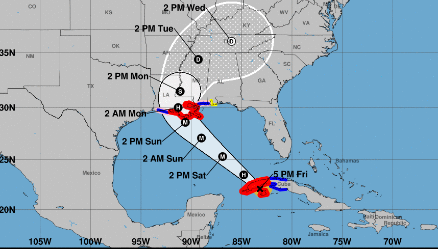
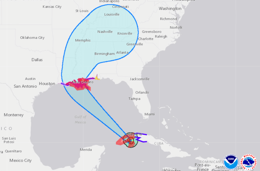
Hurricane Ida is currently 90 miles southwest of Havana, Cuba moving toward the northwest near 15 mph. Ida will pass over western Cuba Friday evening and then move over the southeastern and central Gulf of Mexico Friday night and Saturday. Ida is forecast to make landfall along the U.S. Central Gulf coast on Sunday.
Maximum sustained winds have increased to near 80 mph and a steady to rapid strengthening is expected when Ida moves over the southeastern and central Gulf of Mexico this weekend. The storm is expected to be an extremely dangerous major hurricane when it approaches the Central Gulf coast on Sunday. Presently, a Hurricane Watch is in effect for Cameron Louisiana to west of Intracoastal City, Louisiana and from the mouth of the Pearl River to the Mississippi/Alabama border. A Tropical Storm Watch is in effect for the Mississippi/Alabama border to the Alabama/Florida border.
Ida – Update from the National Hurricane Center
According to the National Hurricane Center’s Advisory #06, issued at 2100z:
At 500 PM EDT (2100 UTC), the center of Hurricane Ida was located near latitude 22.1 North, longitude 83.2 West. Ida is moving toward the northwest near 15 mph (24 km/h), and this general motion should continue until Ida reaches the northern Gulf coast on Sunday. A slower northward motion is forecast after Ida reaches the northern Gulf coast. On the forecast track, the center of Ida will pass over western Cuba during the next several hours, and then move over the southeastern and central Gulf of Mexico later tonight and Saturday. Ida is forecast to make landfall along the U.S. northern Gulf coast within the hurricane warning area on Sunday.
Maximum sustained winds have increased to near 80 mph (130 km/h) with higher gusts. Little change in strength is anticipated while Ida moves over western Cuba this evening. Steady to rapid strengthening is expected when Ida moves over the southeastern and central Gulf of Mexico over the weekend, and Ida is expected to be an extremely dangerous major hurricane when it approaches the northern Gulf coast on Sunday.
Hurricane-force winds extend outward up to 25 miles (35 km) from the center and tropical-storm-force winds extend outward up to 90 miles (150 km). A wind gust to 46 mph (74 km/h) has recently been reported on Cayo Largo, Cuba.
The estimated minimum central pressure is 985 mb (29.09 inches).
Airport & Equipment Information
There are no currently no airport closures, protective shutdowns or outages to equipment at this time.
Route Information
While Kingston, Jamaica Approach works to repair a Mt Denham radar outage due to Ida’s recent passage, their FMU advises that the daily traffic management measures can be avoided by filing routes through their west sector. They advise that traffic management initiatives only apply to aircraft that file through their east sector; if you have the option, it is advised to file west sectors inbound to the island, around the area impacted by the outage.