
Updated Aug. 30, 2023 – 1243z
- Overview
- Update from the National Hurricane Center
- Airport & Equipment Information
- Route Information
- Operational Resources
- NBAA’s HERO Database
Overview
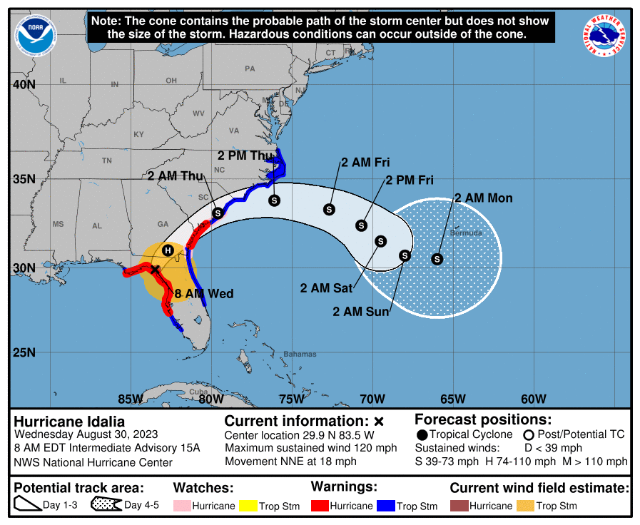
Hurricane Idalia strengthened to a Category 4 hurricane this morning and made landfall at Keaton Beach, FL. Maximum sustained winds are peaking at 120 mph as the storm tracks North by Northeast, or 020°, at 18 mph. Hurricane conditions are expected along much of Florida’s Gulf Coast this morning, as well as across Northern Florida, Southern Georgia and Southern South Carolina. Idalia is expected to be inland over Northern Florida for the next 24 hours, and move offshore to the East through South Carolina tomorrow, with an arcing path that ends south of Bermuda. A storm surge warning has been issued from St. Catherine’s Sound to South Santee River. A hurricane warning has been issued for the East Coast of the United States from Altamaha South, Georgia to Edisto Beach, South Carolina. Additionally, a tropical storm warning has been issued from North of Surf City, North Carolina, to the North Carolina/Virginia border, and including Pamlico and Albemarle Sounds.
Update from the National Hurricane Center
According to the National Hurricane Center’s Advisory #45, issued at 1238z:
Idalia continues to undergo rapid intensification. Maximum flight-level winds were 123 kt, with believable SFMR values of 115 kt. Satellite images show a small eye surrounded by very cold cloud tops, especially in the western quadrant. The initial wind speed is set to 115 kt, making Idalia an extremely dangerous category 4 hurricane.
The hurricane still has a few hours left to intensify before it makes landfall. The biggest change to the intensity forecast is to increase the wind speeds over southeastern Georgia and South Carolina as the rapid motion and track close to the coast is expected to keep the system near hurricane strength for longer. Thus a Hurricane Warning has been issued for a portion of those coasts, and the Hurricane Watch is extended northeastward. After the hurricane moves offshore, the wind field on the northwestern side near eastern North Carolina is expected to be enhanced by a cold front, and the Tropical Storm Watch has been upgraded to a Tropical Storm Warning in that area. The long-range intensity forecast is quite uncertain with Idalia taking on some hybrid characteristics due to a baroclinic trough. No changes were made at this time, and the forecast remains close to the consensus.
Idalia is moving faster toward the north-northeast or 025/16 kt. After landfall, Idalia is expected to move near or along the coast of Georgia and the Carolinas in 24-36 hours. Uncertainty in the track forecast beyond 48 hours remains quite large, and the latest guidance is significantly faster. The new forecast is adjusted toward the consensus, but could be too slow at long range.
KEY MESSAGES:
- Catastrophic impacts from storm surge inundation of 12 to 16 feet above ground level and destructive waves are expected somewhere between the Wakulla/Jefferson County line and Yankeetown, Florida. Life-threatening storm surge inundation is likely elsewhere along portions of the Florida Gulf Coast where a Storm Surge Warning is in effect. Residents in these areas should follow any advice given by local officials.
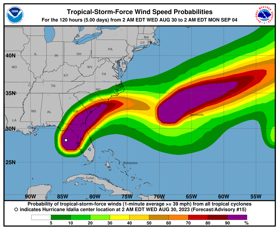
- Destructive life-threatening winds will occur where the core of Idalia moves onshore in the Big Bend region of Florida, with hurricane conditions expected elsewhere in portions of the Hurricane Warning area along the Florida Gulf Coast. Strong winds will also spread inland across portions of northern Florida and southern Georgia near the track of the center of Idalia where Hurricane Warnings are in effect. Residents in these areas should be prepared for long-duration power outages. Damaging hurricane-force winds are likely in portions of eastern Georgia and southeastern South Carolina where Hurricane Warnings are now in effect.
- Areas of flash, urban, and moderate river flooding, with considerable impacts, are expected from the Florida Big Ben through, central Georgia and South Carolina, through eastern North Carolina into Thursday.
Airport & Equipment Information
Airport Closures
Protective Shutdowns
FLORIDA
- GAINESVILLE, FL (GNV) ASR/MODES 0829/2100-0831/1000Z.
- JACKSONVILLE, FL (NIP) VOR 0829/1500-0901/0100.
- ST PETERSBURG, FL (PIE) ATCT 0829/1900-0901/1400Z.
- ST PETERSBURG, FL (PIE) RVR 0828/1600-0830/2000Z.
- ST PETERSBURG, FL (PIE) RWY 18 (PIE) MALSR 0828/1600-0830/2000Z.
- ST PETERSBURG, FL (PIE) SAWS 0829/1830-0830/1900Z.
- SARASOTA, FL (SRQ) RWY 14 (FFV) MALSR 0828/1600-0830/2000Z.
- SARASOTA, FL (SRQ) RWY 32 (SRQ) MALSR 0828/1600-0830/2000Z.
- SARASOTA, FL (SRQ) SAWS 0828/1600-0830/2000Z.
- SARASOTA, FL (SRQ) ASR/MODES/WSP 0829/2200-0830/1300Z.
- TALLAHASSEE, FL (TLH) ATCT 0830/0300-0901/2200Z.
- TAMPA, FL (TPA) RVR 0829/1230-0831/1630Z.
- TAMPA, FL (TPA) ASR/MODES 0829/2200-0830/1700Z.
- TAMPA, FL (TPA) RWY 19L (TPA) LOC/GS 0829/1100-0831/1600Z
- TAMPA, FL (TPA) RWY 19L (TPA) ALS 0829/1230-0831/1630Z.
- TAMPA, FL (TPA) RWY 19L (TPA) PAPI 0829/1230-0831/1630Z.
- TAMPA, FL (TPA) RWY 01L (AMP) LOC/GS 0829/1100-0831/1600Z.
- TAMPA, FL (TPA) RWY 01L (AMP) ALS 0829/1230-0831/1730Z.
- TAMPA, FL (TPA) RWY 01L (AMP) PAPI 0829/1230-0831/1630Z.
- TAMPA, FL (TPA) RWY O1R (TWJ) PAPI 0829/1230-0831/1630Z.
- TAMPA, FL (TPA) RWY 19R (JRT) MALSR 0829/1230-0831/1630Z.
- TAMPA, FL (TPA) RWY 19R (JRT) PAPI 0829/1230-0831/1630Z.
- TAMPA, FL (TPA) RWY 29 (TPAA) PAPI 0829/1230-0831/1630Z.
- TAMPA, FL (TPA) RWY 10 (TPAB) PAPI 0829/1230-0831/1630Z.
- WHITEHOUSE, FL (NEN) NDAG 0829/1400-0831/1200Z.
GEORGIA:
- SAVANNAH, GA (SAV) RVR 0829/1900-0831/2000Z.
- STATESBORO, GA (TBR) RYW 32 (BZQ) 0829/1500-0901/1600Z.
- STATESBORO, GA (TBR) FCOM 0829/1700-0901/1700Z.
- STATESBORO, GA (TBR) RCO 0829/1700-0901/1600Z.
- WAYCROSS, GA (AYS) RWY 19 (AYS) MALSR 0829/1600-0901/1600Z.
Unscheduled System Failures
FLORIDA:
- CROSS CITY, FL (CTY) VOR 0830/1012Z.
- SARASOTA, FL (SRQ) VOR 0830/1021Z.
Route Information
Y280, Y290, Q100, Q102, M215, and M219 are closed until 15z. Additional or extended Gulf Q & Y route closures are possible after 15z.
Operational Resources
- National Hurricane Center
- FAA OIS page
- CADENA OIS page
- FAA Advisory Database
- FAA Current Reroutes
- FAA NOTAM Search
NBAA’s HERO Database
The NBAA Humanitarian Emergency Response Operator (HERO) Database is a list of people in the business aviation community who are part of disaster-response mobilization efforts. In the aftermath of major crises, basic information from the database is provided to organizations coordinating relief efforts. Learn more and register.