Updated Sept. 15, 2020 – 2325
- Overview
- Update from the National Hurricane Center
- Airport & Equipment Information
- Route Information
- Operational Resources
- NBAA’s HERO Database
Overview
Hurricane Sally is moving north at a crawl, barely 2 knots. This means that the Gulf coast will see prolonged exposure to tropical storm force winds over a large area and some hurricane strength winds over a smaller area close to shore. These spinning bands of thunderstorms will bring life-threatening flash flood threats due to the excessive and slow moving rain. The storm surge being pushed inland will only increase the flooding threat. The spinning bands will also increase the potential for tornadoes embedded in the bands of thunderstorms.
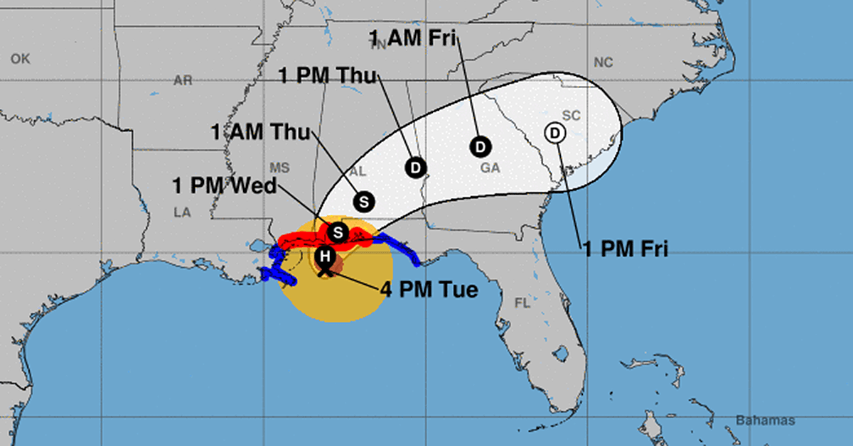
Update from the National Hurricane Center

According to the National Hurricane Center’s Advisory #18, issued at 2100z:
At 400 PM CDT (2100 UTC), the center of Hurricane Sally was located near latitude 29.5 North, longitude 88.1 West. Sally is moving toward the north near 2 mph (4 km/h). A slow northward motion is expected tonight, followed by a slow north-northeastward to northeastward motion on Wednesday and Wednesday night. A slightly faster northeastward motion is expected on Thursday. On the forecast track, the center of Sally will approach the northern Gulf Coast tonight, and make landfall in the hurricane warning area late tonight or Wednesday. Sally is expected to move inland across southeastern Alabama Wednesday night and Thursday.
Data from a NOAA Hurricane Hunter aircraft and NWS Doppler radar indicates that maximum sustained winds are near 80 mph (130 km/h) with higher gusts. Little change in strength is forecast until landfall occurs and Sally is expected to be a dangerous hurricane when it moves onshore along the north-central Gulf Coast.
Hurricane-force winds extend outward up to 40 miles (65 km) from the center and tropical-storm-force winds extend outward up to 125 miles (205 km). A NOAA buoy located about 50 miles (80 km) southeast of Mobile, Alabama, recently reported sustained winds of 58 mph (94 km/h) and a gust to 67 mph (108 km/h) within the past couple of hours. An observing site at the Okaloosa Fishing Pier in Florida has reported sustained winds of 44 mph (70 km/h) and a gust to 52 mph (83 km/h).
The latest minimum central pressure estimated from reconnaissance aircraft data is 979 mb (28.91 inches).
Airport & Equipment Information
Airport closures from the FAA OIS page:
- 0R1 – scheduled to close 9/18 at 13z, scheduled to reopen 9/26 at 13z
- 4R9 – closed – scheduled to reopen 9/17 at 18z
- CEW – closed – scheduled to reopen 9/17 at 17z
- CQF – Fixed Base Operation closed – scheduled to reopen 9/16 at 01z
- DTS – closed – scheduled to reopen 9/17 at 18z
- PNS – closed to fixed wing aircraft – scheduled to reopen 9/16 at 21z
Equipment and service outages from the FAA Advisory Database via the National Operations Control Center (NOCC):
- PENSACOLA, FL (PNS) ASR/MODES PROTECTIVE SHUTDOWN.
- WHITING FIELD, FL (NSE) ASR/MODES PROTECTIVE SHUTDOWN.
- DESTIN, FL (DTS) ATCT CLOSED.
- GULFPORT, MS (GPT) ATCT CLOSED.
- GULFPORT, MS (GPT) RWY 32 (UXI) ALS PROTECTIVE SHUTDOWN.
- GULFPORT, MS (GPT) RWY 14 (GPT) ALS PROTECTIVE SHUTDOWN.
- GULFPORT, MS (GPT) ASR/MODES PROTECTIVE SHUTDOWN.
- BAY ST. LOUIS, MS RWY 18 (HSA) ALS PROTECTIE SHUTDOWN.
- PASCAGOULA, MS (PQL) RWY 17 (PQL) ALS PROTECTIVE SHUTDOWN.
- MOBILE, AL (MOB) ATCT CLOSED.
- MOBILE, AL (MOB) ASR/MODES PROTECTIVE SHUTDOWN.
NOTAMs are the best source of information regarding airport, equipment and facility status. NBAA Air Traffic Services recommends that operators check with FBOs and local contacts to determine if there are any issues with transportation and infrastructure off the airport.
Route Information
Route Closures
Currently Q100, Q102, & Y280 between LEV and SRQ and Y290 between LEV and BAGGS are closed due to thunderstorms. This is expected to continue through 01z, but the routes could open sooner depending on how quickly the storms moves.
Operational Resources
- National Hurricane Center
- FAA OIS page
- CADENA OIS page
- FAA Advisory Database
- FAA Current Reroutes
- FAA NOTAM Search
NBAA’s HERO Database
The NBAA Humanitarian Emergency Response Operator (HERO) Database is a list of people in the business aviation community who are part of disaster-response mobilization efforts. In the aftermath of major crises, basic information from the database is provided to organizations coordinating relief efforts. Learn more and register.