Updated Aug. 31, 2023 – 1230z
- Overview
- Update from the National Hurricane Center
- Airport & Equipment Information
- Route Information
- Operational Resources
- NBAA’s HERO Database
Overview
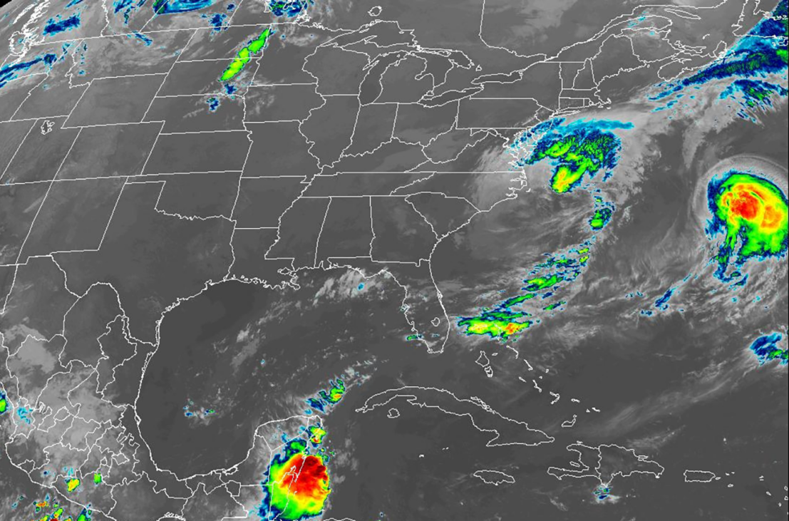
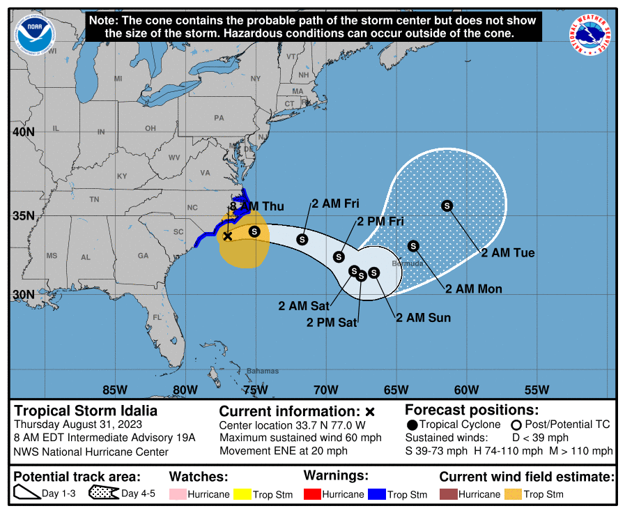
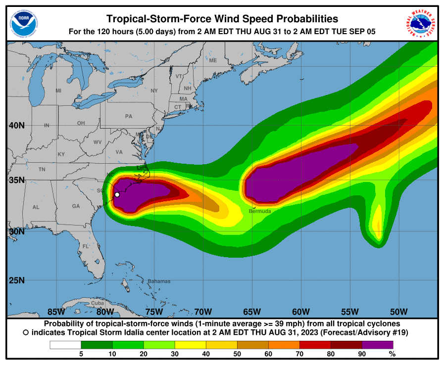
This is the final FAA update for Idalia. Although Idalia was reduced to Tropical Storm status, we could still see damaging impacts today in coastal North Carolina. Idalia is currently 40 miles south of Wilmington, NC, moving East by Northeast, or 075°, at 21 mph. Maximum sustained winds are still reaching 60 mph and minimum central pressure at 29.27 inHg. Today, Idalia will continue to move offshore as it’s being pushed East by the cold front descending out of the Northeast. Over the next few days, Idalia is expected to turn Southeast before turning toward Bermuda while gradually weakening. A Tropical Storm Warning remains in place for South Santee River northward to the North Carolina/Virginia border, and Pamlico and Albemarle Sounds. A storm surge watch is in effect for Beaufort Inlet to Ocracoke Inlet in North Carolina, and Neuse and Pamlico Rivers in North Carolina.
Update from the National Hurricane Center
According to the National Hurricane Center’s Advisory #31, issued at 1230z:
Surface observations from around 0600 UTC showed that the center of Idalia moved offshore of the coast of northeastern South Carolina. Strong southwesterly vertical wind shear has displaced the deep convective bands and heavy rainfall well north and northeast of the center over eastern North Carolina and the adjacent Atlantic. A partial ASCAT-B overpass over the southeastern portion of the circulation revealed winds of 40-45 kt and given that instrument’s typical undersampling, the initial wind speed is maintained at 50 kt for this advisory.
Idalia has turned east-northeastward between a mid-level anticyclone over the Bahamas and a mid-tropospheric trough moving eastward over the northeastern United States. The anticyclone is forecast to retrograde over Florida during the next couple of days, causing Idalia to turn east-southeastward tonight and Friday. After that time, steering currents are predicted to weaken and the cyclone is expected to move very slowly to the southwest of Bermuda during the weekend. By early next week, another mid-latitude trough moving off the northeast U.S. coast should cause Idalia to begin moving northeastward, however there is still significant uncertainty in the details of the track forecast later in the period.
Little change in strength is predicted today, but strong upper-level winds and drier mid-level air are likely to cause some gradual weakening by the weekend. Simulated satellite imagery from the GFS and ECMWF models suggest that the system could lose organized deep convection as soon as tonight, and Idalia could degenerate into a post-tropical cyclone in a day or so. However, the ECMWF does show a return of deep convection over the weekend so the official forecast continues to retain the system as a tropical storm throughout the forecast period.
KEY MESSAGES:
- Areas of flash, urban, and moderate river flooding, with considerable impacts, will continue across coastal North Carolina through today.
- Coastal flooding is expected within the Storm Surge Watch area in North Carolina today. Residents in these areas should follow any advice given by local officials.
- Tropical storm conditions are expected in northeastern South Carolina and portions of eastern North Carolina today.
Airport & Equipment Information
Airport Closures
Protective Shutdowns
FLORIDA
- GAINESVILLE, FL (GNV) ASR/MODES 0829/2100-0831/1000Z.
- JACKSONVILLE, FL (NIP) VOR 0829/1500-0901/0100
- ST PETERSBURG, FL (PIE) RVR 0828/1600-0830/2000Z.
- TAMPA, FL (TPA) RVR 0829/1230-0831/1630Z.
- TAMPA, FL (TPA) RWY 19L (TPA) LOC/GS 0829/1100-0831/1600Z
- TAMPA, FL (TPA) RWY 19L (TPA) ALS 0829/1230-0831/1630Z.
- TAMPA, FL (TPA) RWY 19L (TPA) PAPI 0829/1230-0831/1630Z.
- TAMPA, FL (TPA) RWY 01L (AMP) LOC/GS 0829/1100-0831/1600Z.
- TAMPA, FL (TPA) RWY 01L (AMP) ALS 0829/1230-0831/1730Z.
- TAMPA, FL (TPA) RWY 01L (AMP) PAPI 0829/1230-0831/1630Z.
- TAMPA, FL (TPA) RWY 19R (JRT) MALSR 0829/1230-0831/1630Z.
- TAMPA, FL (TPA) RWY 19R (JRT) PAPI 0829/1230-0831/1630Z.
- TAMPA, FL (TPA) RWY 29 (TPAA) PAPI 0829/1230-0831/1630Z.
- TAMPA, FL (TPA) RWY 10 (TPAB) PAPI 0829/1230-0831/1630Z.
- WHITEHOUSE, FL (NEN) NDAG 0829/1400-0831/1200Z.
GEORGIA:
- FORT STEWART, GA (LHW) ASR 0830/1300-0831/1300Z.
- SAVANNAH, GA (SAV) ATCT ATC ZERO 0830/1359-0831/1300Z.
- SAVANNAH, GA (SAV) ASR/MODES 0830/1145-0901/1600Z.
- SAVANNAH, GA (SAV) RVR 0829/1900-0831/2000Z.
- STATESBORO, GA (TBR) RYW 32 (BZQ) 0829/1500-0901/1600Z.
- STATESBORO, GA (TBR) RCO 0829/1700-0901/1600Z.
- WAYCROSS, GA (AYS) RWY 19 (AYS) MALSR 0829/1600-0901/1600Z.
Unscheduled System Failures
FLORIDA:
- CEDAR KEY, FL (CDK) GBTS 0830/0914Z.
- CROSS CITY, FL (CTY) VOR 0830/1012Z.
- LIVE OAK, FL (24J) GBTS 0830/1213Z.
GEORGIA:
- SAVANNAH, GA (SAV) TACAN 0830/1114Z.
- THOMPSON, GA (HQU) RTR FREQUENCY 124.45 0830/1720Z.
SOUTH CAROLINA:
- GEORGETOWN, SC (GGE) GBTS 0830/2200Zz
DATES/TIMES SUBJECT TO CHANGE DUE TO STORM TRACKING. PLEASE REFER TO NOTAMS FOR ADDITIONAL INFORMATION.
Route Information
** Refer to current NOTAMs/Advisories for updates. **
Operational Resources
- National Hurricane Center
- FAA OIS page
- CADENA OIS page
- FAA Advisory Database
- FAA Current Reroutes
- FAA NOTAM Search
NBAA’s HERO Database
The NBAA Humanitarian Emergency Response Operator (HERO) Database is a list of people in the business aviation community who are part of disaster-response mobilization efforts. In the aftermath of major crises, basic information from the database is provided to organizations coordinating relief efforts. Learn more and register.